
Fai una donazione
Preparati per la tua prossima avventura:
In qualità di associato Amazon, questo sito riceve una commissione sugli acquisti idonei senza alcun costo aggiuntivo per te.
Mappa topografica Hanging Rock State Park
Clicca sulla mappa per visualizzare l'altitudine.
Fai una donazione
Preparati per la tua prossima avventura:
In qualità di associato Amazon, questo sito riceve una commissione sugli acquisti idonei senza alcun costo aggiuntivo per te.
Hanging Rock State Park
Hanging Rock State Park is located in the Sauratown Mountain Range, one of the most easterly mountain ranges in the state. Often called "the mountains away from the mountains," the Sauratown range is made up of monadnocks that are separated from the nearby Blue Ridge Mountains. The Sauratown Mountains lie completely within the borders of Stokes and Surry counties. Prominent peaks in the Sauratown range rise from 1,700 feet (520 m) to more than 2,500 feet (760 m) in elevation and stand in bold contrast to the surrounding countryside, which averages only 800 feet (240 m) in elevation. The most well known peak in the range is Pilot Mountain in nearby Pilot Mountain State Park. The highest point in the park – and the highest point in the Sauratown Mountain range – is Moore's Knob. It rises to 2,579 feet (786 m) above sea level.
Fai una donazione
Preparati per la tua prossima avventura:
In qualità di associato Amazon, questo sito riceve una commissione sugli acquisti idonei senza alcun costo aggiuntivo per te.
A proposito di questa mappa
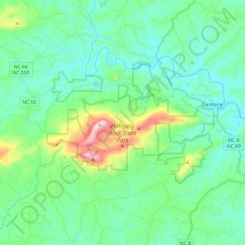
Nome: Mappa topografica Hanging Rock State Park, altitudine, rilievo.
Altitudine media: 323 m
Altitudine minima: 207 m
Altitudine massima: 758 m
Fai una donazione
Preparati per la tua prossima avventura:
In qualità di associato Amazon, questo sito riceve una commissione sugli acquisti idonei senza alcun costo aggiuntivo per te.