
Mappa topografica Blanca Peak
Mappa interattiva
Clicca sulla mappa per visualizzare l'altitudine.
A proposito di questa mappa
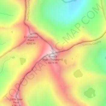
Nome: Mappa topografica Blanca Peak, altitudine, rilievo.
Luogo: Blanca Peak, Alamosa County, Colorado, United States (37.57756 -105.48558 37.57766 -105.48548)
Altitudine media: 3.871 m
Altitudine minima: 3.347 m
Altitudine massima: 4.363 m
Blanca Peak is notable not only for its absolute height, but also for its great local relief and dominant position at the end of the range, rising high above the San Luis Valley to the west. For example, it rises nearly 7,000 feet (2,100 m) over the edge of the San Luis Valley in only 6 miles (9.7 km). Blanca is also the third most topographically prominent peak in Colorado; it is separated from the higher peaks in the Sawatch Range by relatively low Poncha Pass at 9,019 feet (2,749 m).
Altre mappe topografiche
Clicca su una mappa per visualizzarne la topografia, l'altitudine e il rilievo.
Lake Como
United States > Colorado > Alamosa County
Lake Como, Alamosa County, Colorado, United States
Altitudine media: 3.718 m