
Fai una donazione
Preparati per la tua prossima avventura:
In qualità di associato Amazon, questo sito riceve una commissione sugli acquisti idonei senza alcun costo aggiuntivo per te.
Mappa topografica Angeles National Forest
Clicca sulla mappa per visualizzare l'altitudine.
Fai una donazione
Preparati per la tua prossima avventura:
In qualità di associato Amazon, questo sito riceve una commissione sugli acquisti idonei senza alcun costo aggiuntivo per te.
Angeles National Forest
The Angeles National Forest manages the habitats, flora and fauna ecosystems, and watersheds. Some of the rivers with watersheds within its boundaries provide valuable non-groundwater recharge water for Southern California. The existing protected and restored native vegetation absorb and slow surface runoff of rainwater to minimize severe floods and landslides in adjacent communities. The land within the forest is diverse, both in appearance and terrain. Elevations range from 1,200 to 10,064 ft (366 to 3,068 m). The Pacific Crest Trail crosses the forest.
Fai una donazione
Preparati per la tua prossima avventura:
In qualità di associato Amazon, questo sito riceve una commissione sugli acquisti idonei senza alcun costo aggiuntivo per te.
A proposito di questa mappa
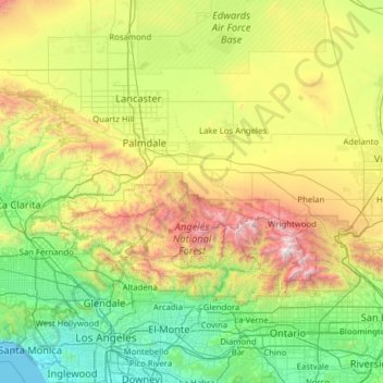
Nome: Mappa topografica Angeles National Forest, altitudine, rilievo.
Altitudine media: 782 m
Altitudine minima: 0 m
Altitudine massima: 3.046 m
Fai una donazione
Preparati per la tua prossima avventura:
In qualità di associato Amazon, questo sito riceve una commissione sugli acquisti idonei senza alcun costo aggiuntivo per te.
Altre mappe topografiche
Clicca su una mappa per visualizzarne la topografia, l'altitudine e il rilievo.
San Gabriel River
United States > California > Los Angeles County > Pico Rivera
Altitudine media: 89 m
Calabasas Highlands
United States > California > Los Angeles County > Calabasas
Altitudine media: 404 m
Fai una donazione
Preparati per la tua prossima avventura:
In qualità di associato Amazon, questo sito riceve una commissione sugli acquisti idonei senza alcun costo aggiuntivo per te.
Mount Wilson Observatory
United States > California > Los Angeles County > Mount Wilson
Altitudine media: 1.421 m
Fai una donazione
Preparati per la tua prossima avventura:
In qualità di associato Amazon, questo sito riceve una commissione sugli acquisti idonei senza alcun costo aggiuntivo per te.
Santa Ynez Reservoir
United States > California > Los Angeles County > Los Angeles
Altitudine media: 307 m
Fai una donazione
Preparati per la tua prossima avventura:
In qualità di associato Amazon, questo sito riceve una commissione sugli acquisti idonei senza alcun costo aggiuntivo per te.
Lake Elizabeth
United States > California > Los Angeles County
The lake, at 984 m (3,228 ft) in elevation, is within the Angeles National Forest. It is a natural perennial lake, but may dry up entirely during drought years. It is south of the western Antelope Valley.
Altitudine media: 1.065 m
Fai una donazione
Preparati per la tua prossima avventura:
In qualità di associato Amazon, questo sito riceve una commissione sugli acquisti idonei senza alcun costo aggiuntivo per te.
Mount Lukens
United States > California > Los Angeles County > Los Angeles
It is in the Sunland-Tujunga community within the northeast corner of the city of Los Angeles, above the Crescenta Valley. The summit, at 5,075 feet (1,547 m) in elevation, is the highest point within the city limits. The summit's elevation makes Los Angeles the city with the largest difference between high…
Altitudine media: 1.176 m
San Pedro Hill
United States > California > Los Angeles County > Rancho Palos Verdes
Altitudine media: 285 m
Hollywood Riviera
United States > California > Los Angeles County > Torrance > Hollywood Riviera
Altitudine media: 50 m
Fai una donazione
Preparati per la tua prossima avventura:
In qualità di associato Amazon, questo sito riceve una commissione sugli acquisti idonei senza alcun costo aggiuntivo per te.
Fai una donazione
Preparati per la tua prossima avventura:
In qualità di associato Amazon, questo sito riceve una commissione sugli acquisti idonei senza alcun costo aggiuntivo per te.
Fai una donazione
Preparati per la tua prossima avventura:
In qualità di associato Amazon, questo sito riceve una commissione sugli acquisti idonei senza alcun costo aggiuntivo per te.
Los Angeles River
United States > California > Los Angeles County > Los Angeles
Altitudine media: 243 m
Fai una donazione
Preparati per la tua prossima avventura:
In qualità di associato Amazon, questo sito riceve una commissione sugli acquisti idonei senza alcun costo aggiuntivo per te.
Avocado Heights
United States > California > Los Angeles County > Avocado Heights
Altitudine media: 112 m
Fai una donazione
Preparati per la tua prossima avventura:
In qualità di associato Amazon, questo sito riceve una commissione sugli acquisti idonei senza alcun costo aggiuntivo per te.
Santa Susana Mountains
United States > California > Los Angeles County > Unincorporated Chatsworth
Altitudine media: 546 m
Woodside Village
United States > California > Los Angeles County > West Covina
Altitudine media: 176 m
Mission Junction
United States > California > Los Angeles County > Los Angeles
Altitudine media: 103 m
Topanga Oaks
United States > California > Los Angeles County > Topanga > Topanga Oaks
Altitudine media: 371 m
Fai una donazione
Preparati per la tua prossima avventura:
In qualità di associato Amazon, questo sito riceve una commissione sugli acquisti idonei senza alcun costo aggiuntivo per te.
Stoneview Nature Center
United States > California > Los Angeles County > Culver City
Altitudine media: 64 m
Fai una donazione
Preparati per la tua prossima avventura:
In qualità di associato Amazon, questo sito riceve una commissione sugli acquisti idonei senza alcun costo aggiuntivo per te.
Golden Shore Marine Biological Reserve
United States > California > Los Angeles County > Long Beach
Altitudine media: 7 m
Fai una donazione
Preparati per la tua prossima avventura:
In qualità di associato Amazon, questo sito riceve una commissione sugli acquisti idonei senza alcun costo aggiuntivo per te.
Adams Square
United States > California > Los Angeles County > Glendale > Adams Square
Altitudine media: 168 m
Fai una donazione
Preparati per la tua prossima avventura:
In qualità di associato Amazon, questo sito riceve una commissione sugli acquisti idonei senza alcun costo aggiuntivo per te.
Edward Vincent Jr. Park
United States > California > Los Angeles County > Inglewood
Altitudine media: 56 m
Fai una donazione
Preparati per la tua prossima avventura:
In qualità di associato Amazon, questo sito riceve una commissione sugli acquisti idonei senza alcun costo aggiuntivo per te.
Augustus F. Hawkins Natural Park
United States > California > Los Angeles County > Los Angeles
Altitudine media: 55 m
Altacanyada
United States > California > Los Angeles County > La Cañada Flintridge
Altitudine media: 584 m
Fai una donazione
Preparati per la tua prossima avventura:
In qualità di associato Amazon, questo sito riceve una commissione sugli acquisti idonei senza alcun costo aggiuntivo per te.
La Puerta Sports Park
United States > California > Los Angeles County > Claremont
Altitudine media: 471 m
Fai una donazione
Preparati per la tua prossima avventura:
In qualità di associato Amazon, questo sito riceve una commissione sugli acquisti idonei senza alcun costo aggiuntivo per te.
Genesee Avenue Park
United States > California > Los Angeles County > Los Angeles
Altitudine media: 33 m
Fai una donazione
Preparati per la tua prossima avventura:
In qualità di associato Amazon, questo sito riceve una commissione sugli acquisti idonei senza alcun costo aggiuntivo per te.
East Rancho Dominguez County Park
United States > California > Los Angeles County > East Compton
Altitudine media: 22 m