
Mappa topografica Cobham
Mappa interattiva
Clicca sulla mappa per visualizzare l'altitudine.
A proposito di questa mappa
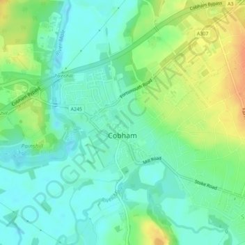
Nome: Mappa topografica Cobham, altitudine, rilievo.
Luogo: Cobham, Elmbridge, Surrey, England, United Kingdom (51.32439 -0.42790 51.33843 -0.39933)
Altitudine media: 28 m
Altitudine minima: 14 m
Altitudine massima: 51 m
The River Mole runs through Cobham, with a visitor area and well-surfaced path by the mill in the High Street, dividing the low-rise urban village/town centre from the remaining agricultural parts of Cobham in the west and south. This can flood small, old parts of the village centre in extreme rainfall. Elevation reaches a minimum here of 20 metres (66 ft) above sea level.[16][17]
Altre mappe topografiche
Clicca su una mappa per visualizzarne la topografia, l'altitudine e il rilievo.
West End
United Kingdom > England > Surrey > Elmbridge
West End, Elmbridge, Surrey, England, KT10 8LY, United Kingdom
Altitudine media: 24 m
Esher
United Kingdom > England > Surrey > Elmbridge
Esher, Elmbridge, Surrey, England, KT10 9QU, United Kingdom
Altitudine media: 27 m