
Fai una donazione
Preparati per la tua prossima avventura:
In qualità di associato Amazon, questo sito riceve una commissione sugli acquisti idonei senza alcun costo aggiuntivo per te.
Mappa topografica Longview
Clicca sulla mappa per visualizzare l'altitudine.
Fai una donazione
Preparati per la tua prossima avventura:
In qualità di associato Amazon, questo sito riceve una commissione sugli acquisti idonei senza alcun costo aggiuntivo per te.
Longview
Longview is located in a small gorge, so its climate varies from that of its close neighbor, Portland. Longview is generally about 7 °F (4 °C) cooler than Portland. Located about 80 miles (130 km) inland across a stretch of relatively flat ground, the Longview skies can be overcast due to moisture from the Pacific Coast marine layer. The Columbia River gorge permits an exchange of air between eastern and western Washington. The direction and speed of air movement through the gorge is determined primarily by the pressure gradient between the eastern and western slopes of the mountains. Due to the gorge-like effect, marine pushes on summer evenings can frequently reach gusts up to 30 to 40 miles per hour (48 to 64 km/h) There have been gusts of up to 90 to 100 miles per hour (140 to 160 km/h), and over 100 miles per hour (160 km/h) at higher elevations.
Fai una donazione
Preparati per la tua prossima avventura:
In qualità di associato Amazon, questo sito riceve una commissione sugli acquisti idonei senza alcun costo aggiuntivo per te.
A proposito di questa mappa
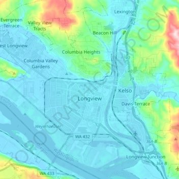
Nome: Mappa topografica Longview, altitudine, rilievo.
Luogo: Longview, Cowlitz County, Washington, 98632, United States (46.10101 -123.03939 46.18358 -122.89172)
Altitudine media: 50 m
Altitudine minima: -5 m
Altitudine massima: 366 m
Fai una donazione
Preparati per la tua prossima avventura:
In qualità di associato Amazon, questo sito riceve una commissione sugli acquisti idonei senza alcun costo aggiuntivo per te.
Altre mappe topografiche
Clicca su una mappa per visualizzarne la topografia, l'altitudine e il rilievo.
Toutle River Sediment Retention Structure
United States > Washington > Cowlitz County
Altitudine media: 347 m
Toutle River Sediment Retention Structure
United States > Washington > Cowlitz County
Altitudine media: 347 m
Fai una donazione
Preparati per la tua prossima avventura:
In qualità di associato Amazon, questo sito riceve una commissione sugli acquisti idonei senza alcun costo aggiuntivo per te.