
Fai una donazione
Preparati per la tua prossima avventura:
In qualità di associato Amazon, questo sito riceve una commissione sugli acquisti idonei senza alcun costo aggiuntivo per te.
Mappa topografica Mima Falls
Clicca sulla mappa per visualizzare l'altitudine.
Fai una donazione
Preparati per la tua prossima avventura:
In qualità di associato Amazon, questo sito riceve una commissione sugli acquisti idonei senza alcun costo aggiuntivo per te.
A proposito di questa mappa
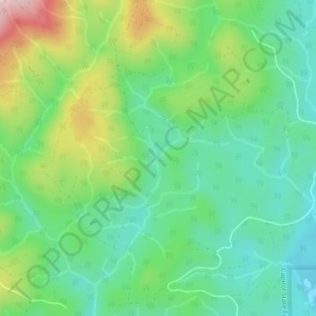
Nome: Mappa topografica Mima Falls, altitudine, rilievo.
Luogo: Mima Falls, Thurston County, Washington, United States (46.91098 -123.08826 46.91108 -123.08816)
Altitudine media: 167 m
Altitudine minima: 74 m
Altitudine massima: 361 m
Fai una donazione
Preparati per la tua prossima avventura:
In qualità di associato Amazon, questo sito riceve una commissione sugli acquisti idonei senza alcun costo aggiuntivo per te.
Altre mappe topografiche
Clicca su una mappa per visualizzarne la topografia, l'altitudine e il rilievo.
Olympia
United States > Washington > Thurston County
Olympia is characterized by a diverse topography that ranges from coastal lowlands to the gently sloping Cascade foothills to the southeast. The city is perched at an average elevation of about 150 feet above sea level, lying adjacent to Budd Inlet and surrounded by rich, green hills that rise gradually from…
Altitudine media: 49 m
Fai una donazione
Preparati per la tua prossima avventura:
In qualità di associato Amazon, questo sito riceve una commissione sugli acquisti idonei senza alcun costo aggiuntivo per te.
Centralia Coal Mine Dam No 32B
United States > Washington > Thurston County > Tono
Altitudine media: 104 m
Fai una donazione
Preparati per la tua prossima avventura:
In qualità di associato Amazon, questo sito riceve una commissione sugli acquisti idonei senza alcun costo aggiuntivo per te.
Olympia
United States > Washington > Thurston County
The area is located near the southern limit of the Fraser Glaciation and the underlying sediments consist largely of Vashon-age till and outwash deposited at that time; the area also includes former lakebeds and alluvial deposits associated with proglacial lakes that existed in the area near the end of…
Altitudine media: 49 m
Fai una donazione
Preparati per la tua prossima avventura:
In qualità di associato Amazon, questo sito riceve una commissione sugli acquisti idonei senza alcun costo aggiuntivo per te.
Olympia
United States > Washington > Thurston County
The area is located near the southern limit of the Fraser Glaciation and the underlying sediments consist largely of Vashon-age till and outwash deposited at that time; the area also includes former lakebeds and alluvial deposits associated with proglacial lakes that existed in the area near the end of…
Altitudine media: 49 m
Fai una donazione
Preparati per la tua prossima avventura:
In qualità di associato Amazon, questo sito riceve una commissione sugli acquisti idonei senza alcun costo aggiuntivo per te.