
Fai una donazione
Preparati per la tua prossima avventura:
In qualità di associato Amazon, questo sito riceve una commissione sugli acquisti idonei senza alcun costo aggiuntivo per te.
Mappa topografica Barweiler
Clicca sulla mappa per visualizzare l'altitudine.
Fai una donazione
Preparati per la tua prossima avventura:
In qualità di associato Amazon, questo sito riceve una commissione sugli acquisti idonei senza alcun costo aggiuntivo per te.
A proposito di questa mappa
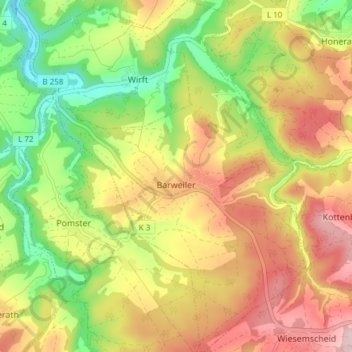
Nome: Mappa topografica Barweiler, altitudine, rilievo.
Altitudine media: 430 m
Altitudine minima: 303 m
Altitudine massima: 558 m
Fai una donazione
Preparati per la tua prossima avventura:
In qualità di associato Amazon, questo sito riceve una commissione sugli acquisti idonei senza alcun costo aggiuntivo per te.
Altre mappe topografiche
Clicca su una mappa per visualizzarne la topografia, l'altitudine e il rilievo.
Eifel
Germany > Rhineland-Palatinate > Landkreis Ahrweiler > Adenau
The Eifel is in the Atlantic climate zone with its relatively high precipitation; winters that are moderately cold and long with periods of snow; and summers that are often humid and cool. The prevailing wind is west/southwest. A relatively dry and milder climate prevails in the wind and rain shadow of the…
Altitudine media: 585 m
Fai una donazione
Preparati per la tua prossima avventura:
In qualità di associato Amazon, questo sito riceve una commissione sugli acquisti idonei senza alcun costo aggiuntivo per te.
Eifel
Germany > Rhineland-Palatinate > Landkreis Ahrweiler > Adenau
The Eifel is in the Atlantic climate zone with its relatively high precipitation; winters that are moderately cold and long with periods of snow; and summers that are often humid and cool. The prevailing wind is west/southwest. A relatively dry and milder climate prevails in the wind and rain shadow of the…
Altitudine media: 585 m