
Mappa topografica Red Lodge
Mappa interattiva
Clicca sulla mappa per visualizzare l'altitudine.
A proposito di questa mappa
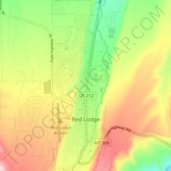
Nome: Mappa topografica Red Lodge, altitudine, rilievo.
Luogo: Red Lodge, Carbon County, Montana, 59068, United States (45.17150 -109.26051 45.21889 -109.23767)
Altitudine media: 1.720 m
Altitudine minima: 1.595 m
Altitudine massima: 1.850 m
Red Lodge experiences a continental climate (Köppen Dfb) with cold, somewhat dry winters and warm, wetter summers. Summers are cooler than in areas of Montana further north, due to the high elevation. Winters however, are milder than areas further to the east due to the chinook wind influence, as with most of Montana.