
Fai una donazione
Preparati per la tua prossima avventura:
In qualità di associato Amazon, questo sito riceve una commissione sugli acquisti idonei senza alcun costo aggiuntivo per te.
Mappa topografica Mountlake Terrace
Clicca sulla mappa per visualizzare l'altitudine.
Fai una donazione
Preparati per la tua prossima avventura:
In qualità di associato Amazon, questo sito riceve una commissione sugli acquisti idonei senza alcun costo aggiuntivo per te.
Mountlake Terrace
The city sits on a plateau that is elevated from the surrounding landscape, with views of the Olympic and Cascade mountains. The Mountlake Terrace's elevation ranges from 263 to 528 feet (80 to 161 m) above sea level, with an average altitude of 440 feet (130 m). The southwestern portion of the city includes the 100-acre (40 ha) Lake Ballinger, which is fed by Hall Creek from Lynnwood and discharges into McAleer Creek towards Lake Washington. Other portions of Mountlake Terrace lie in the watersheds of Lyon Creek and Swamp Creek, which both drain into Lake Washington.
Fai una donazione
Preparati per la tua prossima avventura:
In qualità di associato Amazon, questo sito riceve una commissione sugli acquisti idonei senza alcun costo aggiuntivo per te.
A proposito di questa mappa
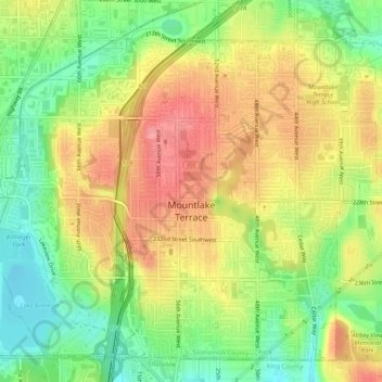
Nome: Mappa topografica Mountlake Terrace, altitudine, rilievo.
Altitudine media: 121 m
Altitudine minima: 77 m
Altitudine massima: 162 m
Fai una donazione
Preparati per la tua prossima avventura:
In qualità di associato Amazon, questo sito riceve una commissione sugli acquisti idonei senza alcun costo aggiuntivo per te.
Altre mappe topografiche
Clicca su una mappa per visualizzarne la topografia, l'altitudine e il rilievo.
Fai una donazione
Preparati per la tua prossima avventura:
In qualità di associato Amazon, questo sito riceve una commissione sugli acquisti idonei senza alcun costo aggiuntivo per te.
Glacier Peak
United States > Washington > Snohomish County
Despite its elevation of 10,541 feet (3,213 m), Glacier Peak is a small stratovolcano. Its relatively high summit is a consequence of its location atop a high ridge, but its volcanic portion extends only 1,600–3,200 feet (500–1,000 m) above the underlying ridge. Another Cascade Arc volcano with similar…
Altitudine media: 2.656 m
Fai una donazione
Preparati per la tua prossima avventura:
In qualità di associato Amazon, questo sito riceve una commissione sugli acquisti idonei senza alcun costo aggiuntivo per te.
Bridal Veil Falls-Lower East Cascade
United States > Washington > Snohomish County
Altitudine media: 621 m
Fai una donazione
Preparati per la tua prossima avventura:
In qualità di associato Amazon, questo sito riceve una commissione sugli acquisti idonei senza alcun costo aggiuntivo per te.
Whitehorse Mountain
United States > Washington > Snohomish County
Whitehorse Mountain is a peak near the western edge of the North Cascades in Washington state. It is located just southwest of the Sauk River Valley town of Darrington, near the northern boundary of Boulder River Wilderness in Mount Baker-Snoqualmie National Forest. While not of particularly high absolute…
Altitudine media: 1.430 m
Fai una donazione
Preparati per la tua prossima avventura:
In qualità di associato Amazon, questo sito riceve una commissione sugli acquisti idonei senza alcun costo aggiuntivo per te.
Mill Creek
United States > Washington > Snohomish County > Mill Creek > Mill Creek
Altitudine media: 129 m
Fai una donazione
Preparati per la tua prossima avventura:
In qualità di associato Amazon, questo sito riceve una commissione sugli acquisti idonei senza alcun costo aggiuntivo per te.