
Mappa topografica Whitworth
Clicca sulla mappa per visualizzare l'altitudine.
A proposito di questa mappa
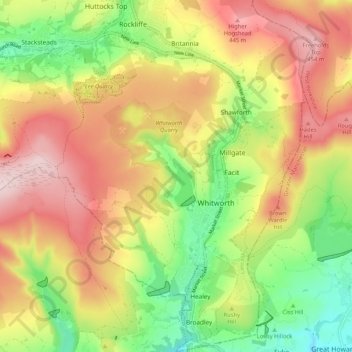
Nome: Mappa topografica Whitworth, altitudine, rilievo.
Altitudine media: 317 m
Altitudine minima: 159 m
Altitudine massima: 477 m
Altre mappe topografiche
Clicca su una mappa per visualizzarne la topografia, l'altitudine e il rilievo.
Bacup
United Kingdom > England > Lancashire > Borough of Rossendale
The geology and topography of the village lent itself to urbanisation and domestic industries; primitive weavers' cottages, coal pits and stone quarries were propelled by Bacup's natural supply of water power in the Early Modern period. The adoption of the factory system, which developed into the Industrial…
Altitudine media: 337 m
Haslingden Grane
United Kingdom > England > Lancashire > Borough of Rossendale > Haslingden
Altitudine media: 287 m
Haslingden Grane
United Kingdom > England > Lancashire > Borough of Rossendale
Altitudine media: 305 m
Irwell Springs
United Kingdom > England > Lancashire > Borough of Rossendale > Weir
Altitudine media: 365 m
Clowbridge
United Kingdom > England > Lancashire > Borough of Rossendale > Habergham Eaves
Altitudine media: 319 m
Whitewell Bottom
United Kingdom > England > Lancashire > Borough of Rossendale > Sagar Holme
Altitudine media: 281 m
Fold Head
United Kingdom > England > Lancashire > Borough of Rossendale > Healey
Altitudine media: 294 m
Trough Gate
United Kingdom > England > Lancashire > Borough of Rossendale > Britannia
Altitudine media: 341 m
Forest Holme
United Kingdom > England > Lancashire > Borough of Rossendale > Water
Altitudine media: 318 m
Nun Hills
United Kingdom > England > Lancashire > Borough of Rossendale > Stacksteads
Altitudine media: 316 m
Cowm Reservoir
United Kingdom > England > Lancashire > Borough of Rossendale > Whitworth > Shawforth
Altitudine media: 302 m
Rake Head
United Kingdom > England > Lancashire > Borough of Rossendale > Stacksteads
Altitudine media: 315 m
Goodshaw Fold
United Kingdom > England > Lancashire > Borough of Rossendale > Loveclough
Altitudine media: 307 m