
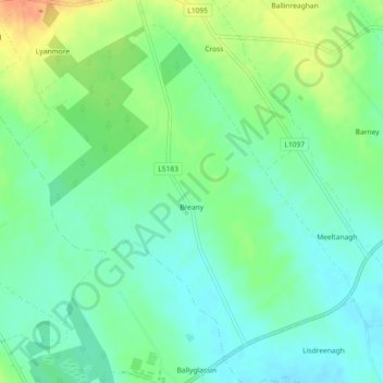
Mappa topografica Breany
Mappa interattiva
Clicca sulla mappa per visualizzare l'altitudine.
A proposito di questa mappa
Nome: Mappa topografica Breany, altitudine, rilievo.
Altitudine media: 91 m
Altitudine minima: 76 m
Altitudine massima: 118 m
Altre mappe topografiche
Clicca su una mappa per visualizzarne la topografia, l'altitudine e il rilievo.
Lanesborough
Lanesborough, Ballymahon Municipal District, County Longford, Leinster, Ireland
Altitudine media: 41 m
Lissardowlan
Lissardowlan, Corboy ED, Longford Municipal District, County Longford, Leinster, Ireland
Altitudine media: 79 m
Annagh More
Annagh More, Mountdavis ED, Ballymahon Municipal District, County Longford, Leinster, Ireland
Altitudine media: 47 m
Laughil
Laughil, Ardagh West ED, Ballymahon Municipal District, County Longford, Leinster, Ireland
Altitudine media: 81 m
Barragh More
Barragh More, Drumlish ED, Granard Municipal District, County Longford, Leinster, Ireland
Altitudine media: 63 m
Cleggill
Cleggill, Caldragh ED, Longford Municipal District, County Longford, Leinster, Ireland
Altitudine media: 48 m
Edgeworthstown
Edgeworthstown, Edgeworthstown ED, Ballymahon Municipal District, County Longford, Leinster, N39 AH64, Ireland
Altitudine media: 94 m
Wood Town
Wood Town, Cloonmore, Killashee ED, Ballymahon Municipal District, County Longford, Leinster, Ireland
Altitudine media: 46 m
Kilshruley
Ireland > County Longford > Kilshruley
Kilshruley, Ballinalee ED, Granard Municipal District, County Longford, Leinster, Ireland
Altitudine media: 66 m
Cloonsheerin
Ireland > County Longford > Cloonsheerin
Cloonsheerin, Killashee ED, Ballymahon Municipal District, County Longford, Leinster, Ireland
Altitudine media: 50 m
Drummeel
Ireland > County Longford > Drummeel
Drummeel, Drummeel ED, Granard Municipal District, County Longford, Leinster, Ireland
Altitudine media: 72 m
Killyfad
Ireland > County Longford > Killyfad
Killyfad, Cloonee ED, Longford Municipal District, County Longford, Leinster, Ireland
Altitudine media: 59 m
Clooneen
Ireland > County Longford > Clooneen
Clooneen, Creevy ED, Granard Municipal District, County Longford, Leinster, Ireland
Altitudine media: 92 m
Elfeet Bay
Elfeet Bay, Cashel West ED, Ballymahon Municipal District, County Longford, Leinster, Ireland
Altitudine media: 40 m
Creagh
Ireland > County Longford > Creagh
Creagh, Kilcommock ED, Ballymahon Municipal District, County Longford, Leinster, Ireland
Altitudine media: 69 m
Longford
Ireland > County Longford > Longford
Longford, County Longford, Leinster, N39 V9W3, Ireland
Altitudine media: 57 m
Lough Gowna
Lough Gowna, Granard Municipal District, County Longford, Leinster, Ireland
Altitudine media: 80 m
Abbeyshrule
Ireland > County Longford > Abbeyshrule
Abbeyshrule, Agharra ED, Ballymahon Municipal District, County Longford, Leinster, Ireland
Altitudine media: 66 m