
Mappa topografica Aniakchak National Monument
Mappa interattiva
Clicca sulla mappa per visualizzare l'altitudine.
A proposito di questa mappa
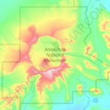
Nome: Mappa topografica Aniakchak National Monument, altitudine, rilievo.
Altitudine media: 376 m
Altitudine minima: 31 m
Altitudine massima: 1.321 m
The national monument is centered on the 6-mile (9.7 km) diameter crater of ancient Mount Aniakchak, which was destroyed and the resulting crater formed during a caldera collapse event about 3,700 years ago. The original mountain, about 7,000 feet (2,100 m) tall, collapsed into its magma chamber, leaving an approximate 3,300-foot (1,000 m) deep summit crater. (The elevation of the high point on the crater rim, Aniakchak Peak, is approximately 4,380 feet. The elevation of the low point of the caldera floor, at the mouth of Surprise Lake and the beginning of the Aniakchak River, is approximately 1,055 feet.) The monument and surrounding preserve include the volcanic feature, the wild Aniakchak River, the Bristol Bay coastal habitat, and portions of the coast of the Pacific Ocean.
Altre mappe topografiche
Clicca su una mappa per visualizzarne la topografia, l'altitudine e il rilievo.
Alagnak River
United States > Alaska > Lake and Peninsula
Alagnak River, Lake and Peninsula, Alaska, United States
Altitudine media: 16 m
Lake Clark
United States > Alaska > Lake and Peninsula
Lake Clark, Lake and Peninsula, Alaska, United States
Altitudine media: 477 m
Port Alsworth
United States > Alaska > Lake and Peninsula
Port Alsworth, Lake and Peninsula, Alaska, 99653, United States
Altitudine media: 93 m
Nondalton
United States > Alaska > Lake and Peninsula
Nondalton, Lake and Peninsula, Alaska, 99640, United States
Altitudine media: 138 m