
Mappa topografica Lakeview
Mappa interattiva
Clicca sulla mappa per visualizzare l'altitudine.
A proposito di questa mappa
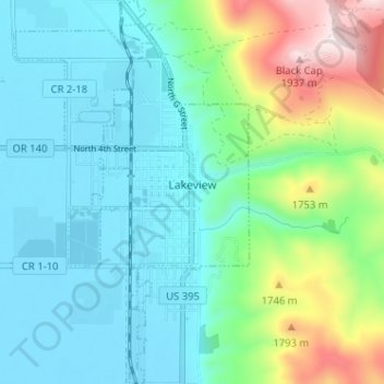
Nome: Mappa topografica Lakeview, altitudine, rilievo.
Luogo: Lakeview, Lake County, Oregon, 97630, United States (42.16423 -120.37558 42.21158 -120.33630)
Altitudine media: 1.562 m
Altitudine minima: 1.440 m
Altitudine massima: 1.960 m
Lakeview is a town in Lake County, Oregon, United States. The population was 2,418 at the 2020 census. It is the county seat of Lake County. The city bills itself as the "Tallest Town in Oregon" because of its elevation, 4,802 feet (1,464 m) above sea level. Lakeview is situated in the Goose Lake Valley at the foot of the Warner Mountains and at the edge of Oregon's high desert country. Its economy is based on agriculture, lumber production, and government activities. In addition, tourism is an increasingly important part of the city's economy. Oregon's Outback Scenic Byway passes through Lakeview.
Altre mappe topografiche
Clicca su una mappa per visualizzarne la topografia, l'altitudine e il rilievo.
Fort Rock
United States > Oregon > Lake County
Fort Rock, Lake County, Oregon, United States
Altitudine media: 1.326 m
Foster Lake
United States > Oregon > Lake County
Foster Lake, Lake County, Oregon, United States
Altitudine media: 1.816 m
Christmas Valley
United States > Oregon > Lake County
Christmas Valley, Lake County, Oregon, 97641, United States
Altitudine media: 1.316 m
Adel
United States > Oregon > Lake County
Adel, Lake County, Oregon, 97620, United States
Altitudine media: 1.467 m
Green Creek
United States > Oregon > Lake County
Green Creek, Lake County, Oregon, United States
Altitudine media: 1.657 m