
Mappa topografica Fritch
Mappa interattiva
Clicca sulla mappa per visualizzare l'altitudine.
A proposito di questa mappa
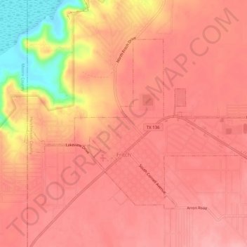
Nome: Mappa topografica Fritch, altitudine, rilievo.
Luogo: Fritch, Hutchinson County, Texas, United States (35.63090 -101.62344 35.65886 -101.57331)
Altitudine media: 965 m
Altitudine minima: 883 m
Altitudine massima: 988 m
Fritch is primarily a bedroom community, with the majority of citizens commuting to nearby Borger and Amarillo for work. Major employers in the area include Pantex, ConocoPhillips, and Agrium, all located within a short distance of Fritch. Due to its nature as a commuting town, Fritch differs from most small towns in the region, which rely more on agriculture as their economic base. Though several large ranches are adjacent to the town, little to no farming occurs due to the uneven topography, and the town has few agriculture-related services.
Altre mappe topografiche
Clicca su una mappa per visualizzarne la topografia, l'altitudine e il rilievo.
Phillips
United States > Texas > Hutchinson County
Phillips, Hutchinson County, Texas, 79007, United States
Altitudine media: 905 m
Stinnett
United States > Texas > Hutchinson County
Stinnett, Hutchinson County, Texas, United States
Altitudine media: 977 m
Lake Meredith
United States > Texas > Hutchinson County
Lake Meredith, Hutchinson County, Texas, United States
Altitudine media: 906 m
Borger
United States > Texas > Hutchinson County
Borger, Hutchinson County, Texas, 79007, United States
Altitudine media: 929 m