
Mappa topografica Thingsulthliah
Clicca sulla mappa per visualizzare l'altitudine.
A proposito di questa mappa
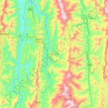
Nome: Mappa topografica Thingsulthliah, altitudine, rilievo.
Luogo: Thingsulthliah, Saitual, Mizoram, India (23.50784 92.78349 23.85040 93.04002)
Altitudine media: 730 m
Altitudine minima: 122 m
Altitudine massima: 1.876 m
Altre mappe topografiche
Clicca su una mappa per visualizzarne la topografia, l'altitudine e il rilievo.
Aizawl
Aizawl has a mild, sub-tropical climate due to its location and elevation. Under the Köppen climate classification, Aizawl features a humid subtropical climate (Cwa). In summer, temperatures are moderately warm, averaging around 20–30 °C (68–86 °F). In winter, daytime temperatures are cooler in…
Altitudine media: 556 m
Aizawl
Aizawl (English: /ˈaɪzɔːl/ EYE-zawl; Mizo: [ˈaɪ̯.ˈzɔːl] ), formerly known as Aijal, is the capital city and the most populous city of Mizoram, India. It is also the third largest city in northeast India. It is situated atop a series of ridges, with an average elevation of around 1,132 metres (3,714…
Altitudine media: 562 m
Aizawl
Aizawl (English: /aɪˈzɔːl/; Mizo: [ˈaɪ̯.ˈzɔːl] ), formerly known as Aijal, is the capital city and the most populous city of Mizoram, India. It is also the third largest city in northeast India, after Guwahati and Agartala. It is situated atop a series of ridges, with an average elevation of around…
Altitudine media: 562 m