
Mappa topografica Moose Factory
Clicca sulla mappa per visualizzare l'altitudine.
A proposito di questa mappa
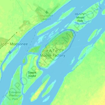
Nome: Mappa topografica Moose Factory, altitudine, rilievo.
Altitudine media: 5 m
Altitudine minima: -6 m
Altitudine massima: 16 m
Altre mappe topografiche
Clicca su una mappa per visualizzarne la topografia, l'altitudine e il rilievo.
Painkiller Lake
Canada > Ontario > Cochrane District > Black River-Matheson Township
Altitudine media: 302 m
Borgford Lake
Canada > Ontario > Cochrane District > Black River-Matheson Township
Altitudine media: 346 m
Kapuskasing
Canada > Ontario > Cochrane District
Kapuskasing lies in the heart of the Great Clay Belt. The topography of the region is very flat, dotted with numerous small lakes and muskeg bogs. Also in the heart of Canada's boreal forest, the region is drained by rivers running north to James Bay. The district is heavily forested, mostly by thick stands of…
Altitudine media: 227 m
Arrow Lake
Canada > Ontario > Cochrane District > Unorganized South West Cochrane
Altitudine media: 297 m
Watersnake Lake
Canada > Ontario > Cochrane District > Fauquier-Strickland Township
Altitudine media: 233 m
Kabinakagami River
Canada > Ontario > Cochrane District > Unorganized North Cochrane
Altitudine media: 250 m
Watabeag River
Canada > Ontario > Cochrane District > Black River-Matheson Township
Altitudine media: 261 m
Ptarmigan Lake
Canada > Ontario > Cochrane District > Unorganized North Cochrane
Altitudine media: 225 m
Moose Factory Island
Canada > Ontario > Cochrane District > Unorganized North Cochrane
Altitudine media: 4 m
Wadsworth Lake
Canada > Ontario > Cochrane District > Unorganized North Cochrane
Altitudine media: 323 m
Cochrane
Canada > Ontario > Cochrane District
Until 1977, Timmins was used as the source for all weather readings attributed to Cochrane except for exceptional extremes, due to the overall similar climate due to proximity and topography. However, in December 1977, Cochrane temperature readings began to be taken from downtown after a noticeable difference…
Altitudine media: 262 m
Ghost Lake;Pearce Creek
Canada > Ontario > Cochrane District > Unorganized North Cochrane
Altitudine media: 213 m
Unorganized South West Cochrane
Canada > Ontario > Cochrane District > Unorganized South West Cochrane
Altitudine media: 312 m
Kapuskasing
Canada > Ontario > Cochrane District
Kapuskasing lies in the heart of the Great Clay Belt. The topography of the region is very flat, dotted with numerous small lakes and muskeg bogs. Also in the heart of Canada's boreal forest, the region is drained by rivers running north to James Bay. The district is heavily forested, mostly by thick stands of…
Altitudine media: 227 m
Moose Factory Island
Canada > Ontario > Cochrane District > Unorganized North Cochrane
Altitudine media: 4 m
Big Cedar Creek
Canada > Ontario > Cochrane District > Unorganized North Cochrane
Altitudine media: 49 m