
Mappa topografica Kootenay National Park
Mappa interattiva
Clicca sulla mappa per visualizzare l'altitudine.
A proposito di questa mappa
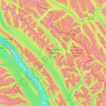
Nome: Mappa topografica Kootenay National Park, altitudine, rilievo.
Altitudine media: 1.833 m
Altitudine minima: 785 m
Altitudine massima: 3.576 m
Kootenay National Park is a national park of Canada located in southeastern British Columbia. The park consists of 1,406 km2 (543 sq mi) of the Canadian Rockies, including parts of the Kootenay and Park mountain ranges, the Kootenay River and the entirety of the Vermilion River. While the Vermilion River is completely contained within the park, the Kootenay River has its headwaters just outside the park boundary, flowing through the park into the Rocky Mountain Trench and eventually joining the Columbia River. The park ranges in elevation from 918 m (3,012 ft) at the southwestern park entrance to 3,424 m (11,234 ft) at Deltaform Mountain.
Altre mappe topografiche
Clicca su una mappa per visualizzarne la topografia, l'altitudine e il rilievo.
Taurus Mountain
Canada > British Columbia > Regional District of East Kootenay > Area G (Forster Creek/Mount Assiniboine)
Taurus Mountain, Area G (Forster Creek/Mount Assiniboine), Regional District of East Kootenay, British Columbia, Canada
Altitudine media: 2.404 m
Minnow Creek
Canada > British Columbia > Regional District of East Kootenay > Area G (Forster Creek/Mount Assiniboine)
Minnow Creek, Area G (Forster Creek/Mount Assiniboine), Regional District of East Kootenay, British Columbia, Canada
Altitudine media: 1.428 m