
Fai una donazione
Preparati per la tua prossima avventura:
In qualità di associato Amazon, questo sito riceve una commissione sugli acquisti idonei senza alcun costo aggiuntivo per te.
Mappa topografica Woodbridge
Clicca sulla mappa per visualizzare l'altitudine.
Fai una donazione
Preparati per la tua prossima avventura:
In qualità di associato Amazon, questo sito riceve una commissione sugli acquisti idonei senza alcun costo aggiuntivo per te.
Woodbridge
The Suffolk Traveller suggests a similar origin to The Dictionary but originating from a bridge over a hollow way that leads from Woodbridge Market Place to the Ipswich. But this is disputed by Rev. Thomas Carthew, then perpetual curate of Woodbridge who points out that the bridge had existed for less than a hundred years at that point and therefore was not old enough to be the source of the name. He instead suggests Oden or Woden (Odin) and Burgh, Bury, or Brigg (town). The Topographical Dictionary of England suggests a combination of Woden and Bryge.
Fai una donazione
Preparati per la tua prossima avventura:
In qualità di associato Amazon, questo sito riceve una commissione sugli acquisti idonei senza alcun costo aggiuntivo per te.
A proposito di questa mappa
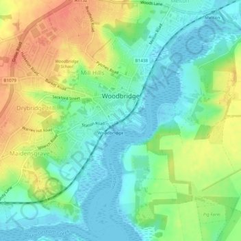
Nome: Mappa topografica Woodbridge, altitudine, rilievo.
Luogo: Woodbridge, East Suffolk, Suffolk, England, United Kingdom (52.07639 1.28439 52.10577 1.32901)
Altitudine media: 19 m
Altitudine minima: -5 m
Altitudine massima: 46 m
Fai una donazione
Preparati per la tua prossima avventura:
In qualità di associato Amazon, questo sito riceve una commissione sugli acquisti idonei senza alcun costo aggiuntivo per te.
Altre mappe topografiche
Clicca su una mappa per visualizzarne la topografia, l'altitudine e il rilievo.
Fai una donazione
Preparati per la tua prossima avventura:
In qualità di associato Amazon, questo sito riceve una commissione sugli acquisti idonei senza alcun costo aggiuntivo per te.
Fai una donazione
Preparati per la tua prossima avventura:
In qualità di associato Amazon, questo sito riceve una commissione sugli acquisti idonei senza alcun costo aggiuntivo per te.
Site of old Orfordness Lighthouse
United Kingdom > England > Suffolk > East Suffolk > Orford
Altitudine media: 0 m
Fai una donazione
Preparati per la tua prossima avventura:
In qualità di associato Amazon, questo sito riceve una commissione sugli acquisti idonei senza alcun costo aggiuntivo per te.
Rendlesham UFO Landing Site #2
United Kingdom > England > Suffolk > East Suffolk > Butley Abbey
Altitudine media: 14 m
Fai una donazione
Preparati per la tua prossima avventura:
In qualità di associato Amazon, questo sito riceve una commissione sugli acquisti idonei senza alcun costo aggiuntivo per te.
Gunton Sands
United Kingdom > England > Suffolk > East Suffolk > Lowestoft > Corton
Altitudine media: 10 m
Lowestoft Inner Harbour
United Kingdom > England > Suffolk > East Suffolk > Lowestoft > Oulton Broad
Altitudine media: 8 m
Sutton Hoo Archeological Site
United Kingdom > England > Suffolk > East Suffolk > Sutton
Altitudine media: 19 m
Fai una donazione
Preparati per la tua prossima avventura:
In qualità di associato Amazon, questo sito riceve una commissione sugli acquisti idonei senza alcun costo aggiuntivo per te.
Fai una donazione
Preparati per la tua prossima avventura:
In qualità di associato Amazon, questo sito riceve una commissione sugli acquisti idonei senza alcun costo aggiuntivo per te.
Eygpt Wood
United Kingdom > England > Suffolk > East Suffolk > Trimley St Martin
Altitudine media: 16 m
Eygpt Wood
United Kingdom > England > Suffolk > East Suffolk > Trimley St Martin
Altitudine media: 16 m