
Mappa topografica Dixville
Mappa interattiva
Clicca sulla mappa per visualizzare l'altitudine.
A proposito di questa mappa
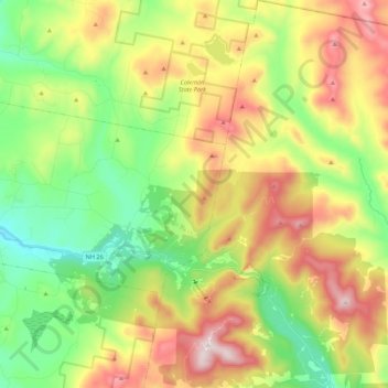
Nome: Mappa topografica Dixville, altitudine, rilievo.
Luogo: Dixville, Coös County, New Hampshire, United States (44.81834 -71.35341 44.97345 -71.21592)
Altitudine media: 635 m
Altitudine minima: 349 m
Altitudine massima: 1.055 m
According to the United States Census Bureau, the township has a total area of 49.2 square miles (127.3 km2), of which 49.0 square miles (126.9 km2) are land and 0.2 square miles (0.4 km2), or 0.35%, are water. Dixville Notch is in the southwest part of the township. With an elevation of 1,887 feet (575 m) above sea level, it is the height of land between west-flowing tributaries of the Connecticut River and east-flowing tributaries of the Androscoggin River. The notch lies within Dixville Notch State Park. (The term "notch" is the local equivalent of "pass" or "gap", and refers to a low place between mountains or mountain ranges.) Nearby Dixville Peak, at 3,482 feet (1,061 m), is the highest point in the township.
Altre mappe topografiche
Clicca su una mappa per visualizzarne la topografia, l'altitudine e il rilievo.
Kidderville
United States > New Hampshire > Coos County > Colebrook
Kidderville, Colebrook, Coös County, New Hampshire, United States
Altitudine media: 472 m
Mount Washington
United States > New Hampshire > Coos County
Mount Washington, Coös County, New Hampshire, United States
Altitudine media: 1.568 m
Northumberland
United States > New Hampshire > Coos County
Northumberland, Coös County, New Hampshire, United States
Altitudine media: 383 m
Stark
United States > New Hampshire > Coos County
Stark, Coös County, New Hampshire, United States
Altitudine media: 526 m
Shelburne
United States > New Hampshire > Coos County
Shelburne, Coös County, New Hampshire, United States
Altitudine media: 467 m
Groveton
United States > New Hampshire > Coos County
Groveton, Northumberland, Coös County, New Hampshire, United States
Altitudine media: 304 m
Columbia
United States > New Hampshire > Coos County
Columbia, Coös County, New Hampshire, United States
Altitudine media: 553 m
Dummer
United States > New Hampshire > Coos County
Dummer, Coös County, New Hampshire, United States
Altitudine media: 419 m
Twin Mountain
United States > New Hampshire > Coos County > Carroll
Twin Mountain, Carroll, Coös County, New Hampshire, 03595, United States
Altitudine media: 490 m
Pinkham Notch
United States > New Hampshire > Coos County
Pinkham Notch, Pinkham's Grant, Coös County, New Hampshire, United States
Altitudine media: 767 m
Milan
United States > New Hampshire > Coos County
Milan, Coös County, New Hampshire, 03588, United States
Altitudine media: 448 m
Stratford
United States > New Hampshire > Coos County
Stratford, Coös County, New Hampshire, 03590, United States
Altitudine media: 497 m
Castellated Ridge
United States > New Hampshire > Coos County
Castellated Ridge, Low and Burbank's Grant, Coös County, New Hampshire, United States
Altitudine media: 1.080 m
Lost Nation
United States > New Hampshire > Coos County > Northumberland
Lost Nation, Northumberland, Coös County, New Hampshire, United States
Altitudine media: 363 m
North Stratford
United States > New Hampshire > Coos County
North Stratford, Stratford, Coös County, New Hampshire, 03590, United States
Altitudine media: 340 m
Colebrook
United States > New Hampshire > Coos County
Colebrook, Coös County, New Hampshire, 03576, United States
Altitudine media: 476 m
Whitefield
United States > New Hampshire > Coos County
Whitefield, Coös County, New Hampshire, United States
Altitudine media: 365 m
Gorham
United States > New Hampshire > Coos County
Gorham, Coös County, New Hampshire, 03581, United States
Altitudine media: 477 m
Wildcat Mountain
United States > New Hampshire > Coos County
Wildcat Mountain, Coös County, New Hampshire, United States
Altitudine media: 1.055 m
Upper Kidderville
United States > New Hampshire > Coos County > Colebrook
Upper Kidderville, Colebrook, Coos County, New Hampshire, United States
Altitudine media: 478 m
Pittsburg
United States > New Hampshire > Coos County
Pittsburg, Coös County, New Hampshire, United States
Altitudine media: 522 m
Castle Mountain
United States > New Hampshire > Coos County
Castle Mountain, Coos County, New Hampshire, United States
Altitudine media: 937 m
Carroll
United States > New Hampshire > Coos County
Carroll, Coös County, New Hampshire, United States
Altitudine media: 562 m
Lancaster
United States > New Hampshire > Coos County
Lancaster, Coös County, New Hampshire, 03584, United States
Altitudine media: 371 m
Bretton Woods
United States > New Hampshire > Coos County > Carroll
Bretton Woods, Carroll, Coös County, New Hampshire, 03575, United States
Altitudine media: 577 m
Clarksville
United States > New Hampshire > Coos County
Clarksville, Coös County, New Hampshire, United States
Altitudine media: 570 m
Mount Crescent
United States > New Hampshire > Coos County
Mount Crescent, Coos County, New Hampshire, 03593, United States
Altitudine media: 748 m
Triple Falls
United States > New Hampshire > Coos County > Gorham
Triple Falls, Gorham, Coos County, New Hampshire, 03593, United States
Altitudine media: 558 m
Randolph
United States > New Hampshire > Coos County
Randolph, Coös County, New Hampshire, 03593, United States
Altitudine media: 594 m
LIttle Diamond Pond
United States > New Hampshire > Coos County > Stewartstown
LIttle Diamond Pond, Stewartstown, Coos County, New Hampshire, United States
Altitudine media: 693 m
Jefferson Highland
United States > New Hampshire > Coos County > Jefferson > Jefferson Highland
Jefferson Highland, Jefferson, Coos County, New Hampshire, 03583, United States
Altitudine media: 451 m
Jefferson
United States > New Hampshire > Coos County
Jefferson, Coös County, New Hampshire, 03583, United States
Altitudine media: 493 m
Dixville Notch
United States > New Hampshire > Coos County
Dixville Notch, Coos County, New Hampshire, United States
Altitudine media: 655 m
Stewartstown
United States > New Hampshire > Coos County
Stewartstown, Coös County, New Hampshire, 03597, United States
Altitudine media: 485 m
Dalton
United States > New Hampshire > Coos County
Dalton, Coös County, New Hampshire, United States
Altitudine media: 375 m
Errol
United States > New Hampshire > Coos County
Errol, Coös County, New Hampshire, United States
Altitudine media: 453 m
Mount Eisenhower
United States > New Hampshire > Coos County
Mount Eisenhower, Coos County, New Hampshire, 03589, United States
Altitudine media: 1.142 m