
Mappa topografica Roche Béranger
Mappa interattiva
Clicca sulla mappa per visualizzare l'altitudine.
A proposito di questa mappa
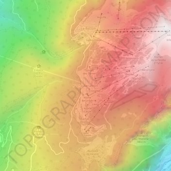
Nome: Mappa topografica Roche Béranger, altitudine, rilievo.
Altitudine media: 1.561 m
Altitudine minima: 539 m
Altitudine massima: 2.250 m
The road to the ski station starts at Uriage-les-Bains from where the climb is 19 km (12 mi) long, gaining 1,235 m (4,052 ft) in elevation, at an average gradient of 6.5%. There are several sections in excess off 11% in the early stages of the climb. For the Tour de France, the summit is at an elevation of 1,730 m (5,680 ft).