
Mappa topografica Poteau
Mappa interattiva
Clicca sulla mappa per visualizzare l'altitudine.
A proposito di questa mappa
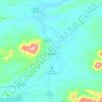
Nome: Mappa topografica Poteau, altitudine, rilievo.
Luogo: Poteau, Le Flore County, Oklahoma, 74953, United States (34.92772 -94.73447 35.20218 -94.57137)
Altitudine media: 189 m
Altitudine minima: 125 m
Altitudine massima: 770 m
The city is located in the valley below Cavanal Hill, dubbed the "World's Highest Hill" with a signed elevation of 1,999 feet (609 m). The location was a subject of extensive coal mining in the first half of the 20th Century, and a railway, eventually called the Poteau and Cavanal Mountain Railroad, served the mines. The summit elevation of the hill is 2,385 feet (727 m) above sea level, while the hill rises 1,960 feet (600 m) above the Poteau River on the east side of Poteau. The Poteau River is the only river in Oklahoma that flows north. It flows into Arkansas where it meets the Arkansas River at Belle Point in Fort Smith.
Altre mappe topografiche
Clicca su una mappa per visualizzarne la topografia, l'altitudine e il rilievo.
Heavener
United States > Oklahoma > Le Flore County
Heavener, Le Flore County, Oklahoma, 74937, United States
Altitudine media: 193 m
Talimena State Park
United States > Oklahoma > Le Flore County
Talimena State Park, Le Flore County, Oklahoma, United States
Altitudine media: 345 m