
Fai una donazione
Preparati per la tua prossima avventura:
In qualità di associato Amazon, questo sito riceve una commissione sugli acquisti idonei senza alcun costo aggiuntivo per te.
Mappa topografica Cooper Landing
Clicca sulla mappa per visualizzare l'altitudine.
Fai una donazione
Preparati per la tua prossima avventura:
In qualità di associato Amazon, questo sito riceve una commissione sugli acquisti idonei senza alcun costo aggiuntivo per te.
Cooper Landing
Cooper Landing is located in the north-central part of the Kenai Peninsula at 60°29′26″N 149°47′40″W / 60.49056°N 149.79444°W / 60.49056; -149.79444 (60.490529, -149.794519). The center of the community is at the west end of Kenai Lake, where the lake flows into the Kenai River. The CDP extends east up Kenai Lake beyond the mouth of Quartz Creek from the north. To the south the CDP reaches Cooper Lake, and Cooper Creek, the lake's outlet, forms a portion of the CDP's southern border. The CDP reaches west down the Kenai River as far as the mouth of the Russian River, and to the north the CDP extends up the valley of Juneau Creek as far as Trout Lake. Elevations in the CDP range from approximately 330 feet (100 m) above sea level at the mouth of the Russian River, to 436 feet (133 m) at Kenai Lake, to 4,576 feet (1,395 m) at the summit of Cecil Rhode Mountain between Kenai Lake and Cooper Creek.
Fai una donazione
Preparati per la tua prossima avventura:
In qualità di associato Amazon, questo sito riceve una commissione sugli acquisti idonei senza alcun costo aggiuntivo per te.
A proposito di questa mappa
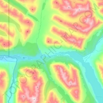
Nome: Mappa topografica Cooper Landing, altitudine, rilievo.
Luogo: Cooper Landing, Kenai Peninsula, Alaska, United States (60.40322 -150.00004 60.58730 -149.67565)
Altitudine media: 608 m
Altitudine minima: 95 m
Altitudine massima: 1.522 m
Fai una donazione
Preparati per la tua prossima avventura:
In qualità di associato Amazon, questo sito riceve una commissione sugli acquisti idonei senza alcun costo aggiuntivo per te.
Altre mappe topografiche
Clicca su una mappa per visualizzarne la topografia, l'altitudine e il rilievo.
Homer
United States > Alaska > Kenai Peninsula > Homer
Some birds seen during the spring migration and the festival include horned puffins, sandhill cranes, and arctic terns. Arctic Terns are famous for flying the longest distance of any migrating bird. Many of the birds seen during the festival can be identified with the help of published guides that categorize…
Altitudine media: 106 m
Fai una donazione
Preparati per la tua prossima avventura:
In qualità di associato Amazon, questo sito riceve una commissione sugli acquisti idonei senza alcun costo aggiuntivo per te.
Fai una donazione
Preparati per la tua prossima avventura:
In qualità di associato Amazon, questo sito riceve una commissione sugli acquisti idonei senza alcun costo aggiuntivo per te.
Fai una donazione
Preparati per la tua prossima avventura:
In qualità di associato Amazon, questo sito riceve una commissione sugli acquisti idonei senza alcun costo aggiuntivo per te.