
Mappa topografica Newmarket
Mappa interattiva
Clicca sulla mappa per visualizzare l'altitudine.
A proposito di questa mappa
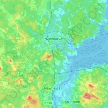
Nome: Mappa topografica Newmarket, altitudine, rilievo.
Altitudine media: 21 m
Altitudine minima: -8 m
Altitudine massima: 85 m
According to the United States Census Bureau, the town has a total area of 14.2 square miles (36.7 km2), of which 12.6 square miles (32.6 km2) are land and 1.6 square miles (4.1 km2) are water, comprising 11.24% of the town. Situated beside Great Bay, Newmarket is drained by the Lamprey River and its tributary, the Piscassic River. The town's highest point is the summit of Bald Hill, at 281 feet (86 m) above sea level, near the town's southwest corner. Great Hill, with an elevation of 228 feet (69 m), rises just south of the town center.