
Fai una donazione
Preparati per la tua prossima avventura:
In qualità di associato Amazon, questo sito riceve una commissione sugli acquisti idonei senza alcun costo aggiuntivo per te.
Mappa topografica Wraysbury
Clicca sulla mappa per visualizzare l'altitudine.
Fai una donazione
Preparati per la tua prossima avventura:
In qualità di associato Amazon, questo sito riceve una commissione sugli acquisti idonei senza alcun costo aggiuntivo per te.
Wraysbury
The new chapel, with its elegant slender tower, was opened on 16 October 1862; the building works had cost around £800. The striking terracotta relief panel, The City of Refuge, on the front elevation of the chapel, was created by the renowned Doulton & Co artist George Tinworth and is signed with his monogram. After Buckland's death, James Doulton, his son-in-law and a cousin of Sir Henry Doulton, took over the preaching duties. Later James' son-in-law the Reverend Arthur Gostick Shorrock took over the duties. Arthur had been a student preacher in Wraysbury in the 1880s, after which he spent 35 years as a missionary in Shaanxi, China.
Fai una donazione
Preparati per la tua prossima avventura:
In qualità di associato Amazon, questo sito riceve una commissione sugli acquisti idonei senza alcun costo aggiuntivo per te.
A proposito di questa mappa
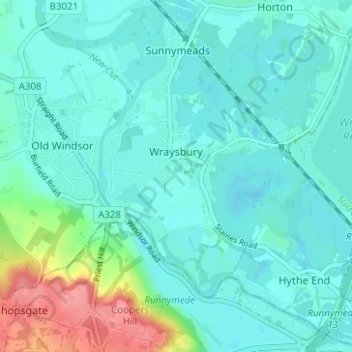
Nome: Mappa topografica Wraysbury, altitudine, rilievo.
Altitudine media: 25 m
Altitudine minima: 10 m
Altitudine massima: 90 m
Fai una donazione
Preparati per la tua prossima avventura:
In qualità di associato Amazon, questo sito riceve una commissione sugli acquisti idonei senza alcun costo aggiuntivo per te.
Altre mappe topografiche
Clicca su una mappa per visualizzarne la topografia, l'altitudine e il rilievo.
Windsor Marina
United Kingdom > England > Royal Borough of Windsor and Maidenhead > Oakley Green
Altitudine media: 26 m
Silwood Park
United Kingdom > England > Royal Borough of Windsor and Maidenhead > Beggar's Bush
Altitudine media: 61 m
Fai una donazione
Preparati per la tua prossima avventura:
In qualità di associato Amazon, questo sito riceve una commissione sugli acquisti idonei senza alcun costo aggiuntivo per te.
Braywoodside
United Kingdom > England > Royal Borough of Windsor and Maidenhead
Altitudine media: 43 m
Cookham Rise
United Kingdom > England > Royal Borough of Windsor and Maidenhead
Altitudine media: 44 m
Fai una donazione
Preparati per la tua prossima avventura:
In qualità di associato Amazon, questo sito riceve una commissione sugli acquisti idonei senza alcun costo aggiuntivo per te.
Magna Carta Island
United Kingdom > England > Royal Borough of Windsor and Maidenhead > Wraysbury
Altitudine media: 32 m
Cookham Dean
United Kingdom > England > Royal Borough of Windsor and Maidenhead
Altitudine media: 50 m
Bridge Gardens
United Kingdom > England > Royal Borough of Windsor and Maidenhead > Maidenhead
Altitudine media: 30 m
Upton Court Park
United Kingdom > England > Royal Borough of Windsor and Maidenhead > Slough
Altitudine media: 23 m
Fai una donazione
Preparati per la tua prossima avventura:
In qualità di associato Amazon, questo sito riceve una commissione sugli acquisti idonei senza alcun costo aggiuntivo per te.
Formosa Island
United Kingdom > England > Royal Borough of Windsor and Maidenhead > Cookham
Altitudine media: 48 m
Burchett's Green
United Kingdom > England > Royal Borough of Windsor and Maidenhead > Hurley
Altitudine media: 68 m
Fai una donazione
Preparati per la tua prossima avventura:
In qualità di associato Amazon, questo sito riceve una commissione sugli acquisti idonei senza alcun costo aggiuntivo per te.
Windsor Castle
United Kingdom > England > Royal Borough of Windsor and Maidenhead > Windsor > Clewer Village
Altitudine media: 23 m
Oakley Green
United Kingdom > England > Royal Borough of Windsor and Maidenhead
Altitudine media: 37 m
Fai una donazione
Preparati per la tua prossima avventura:
In qualità di associato Amazon, questo sito riceve una commissione sugli acquisti idonei senza alcun costo aggiuntivo per te.
Windsor Castle
United Kingdom > England > Royal Borough of Windsor and Maidenhead > Windsor > Clewer Village
Altitudine media: 23 m
Fai una donazione
Preparati per la tua prossima avventura:
In qualità di associato Amazon, questo sito riceve una commissione sugli acquisti idonei senza alcun costo aggiuntivo per te.
Cookham Rise
United Kingdom > England > Royal Borough of Windsor and Maidenhead
Altitudine media: 44 m
Windsor Castle
United Kingdom > England > Royal Borough of Windsor and Maidenhead > Windsor > Clewer Village
Altitudine media: 23 m
Cookham Dean
United Kingdom > England > Royal Borough of Windsor and Maidenhead
Altitudine media: 50 m
Windsor Castle
United Kingdom > England > Royal Borough of Windsor and Maidenhead > Windsor > Clewer Village
Altitudine media: 23 m
Fai una donazione
Preparati per la tua prossima avventura:
In qualità di associato Amazon, questo sito riceve una commissione sugli acquisti idonei senza alcun costo aggiuntivo per te.