
Mappa topografica Tucson
Clicca sulla mappa per visualizzare l'altitudine.
Tucson
By 1900, 7,531 people lived in Tucson. By 1910, the population increased to 13,913. About this time, the U.S. Veterans Administration had begun construction of the present Veterans Hospital. The city's clean, dry air made it a destination for many veterans who had been gassed in World War I and needed respiratory therapy. In addition, these dry and high-altitude conditions were thought to be ideal for the treatment of tuberculosis, for which no cures were known before antibiotics were developed against it.
A proposito di questa mappa
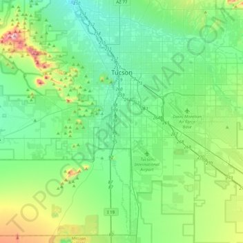
Nome: Mappa topografica Tucson, altitudine, rilievo.
Luogo: Tucson, Pima County, Arizona, United States (31.99041 -111.05823 32.32091 -110.70821)
Altitudine media: 822 m
Altitudine minima: 651 m
Altitudine massima: 1.416 m
Altre mappe topografiche
Clicca su una mappa per visualizzarne la topografia, l'altitudine e il rilievo.
Tucson
United States > Arizona > Pima County > Tucson
The city's elevation is 2,643 ft (806 m) above sea level (as measured at the Tucson International Airport). Tucson is on an alluvial plain in the Sonoran Desert, surrounded by five minor ranges of mountains: the Santa Catalina Mountains and the Tortolita Mountains to the north, the Santa Rita Mountains to the…
Altitudine media: 836 m