
Fai una donazione
Preparati per la tua prossima avventura:
In qualità di associato Amazon, questo sito riceve una commissione sugli acquisti idonei senza alcun costo aggiuntivo per te.
Mappa topografica La Luz
Clicca sulla mappa per visualizzare l'altitudine.
Fai una donazione
Preparati per la tua prossima avventura:
In qualità di associato Amazon, questo sito riceve una commissione sugli acquisti idonei senza alcun costo aggiuntivo per te.
La Luz
The largest employer in the surrounding area is Holloman Air Force Base. La Luz itself is largely residential and agricultural in land use but a small market is located on the state maintained road that connects the village to Highway 70. La Luz has long been known for the many fruits that are grown in the area including figs, apricots, plums and peaches. Apples, cherries, and pears are grown in the higher elevations in the canyon areas to the east of the village. The surrounding area also has a number of vineyards and pistachio groves. A number of artists also reside in the area.
Fai una donazione
Preparati per la tua prossima avventura:
In qualità di associato Amazon, questo sito riceve una commissione sugli acquisti idonei senza alcun costo aggiuntivo per te.
A proposito di questa mappa
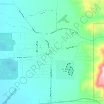
Nome: Mappa topografica La Luz, altitudine, rilievo.
Luogo: La Luz, Otero County, New Mexico, 88337, United States (32.95787 -105.96193 32.99787 -105.92193)
Altitudine media: 1.459 m
Altitudine minima: 1.380 m
Altitudine massima: 1.778 m
Fai una donazione
Preparati per la tua prossima avventura:
In qualità di associato Amazon, questo sito riceve una commissione sugli acquisti idonei senza alcun costo aggiuntivo per te.