
Fai una donazione
Preparati per la tua prossima avventura:
In qualità di associato Amazon, questo sito riceve una commissione sugli acquisti idonei senza alcun costo aggiuntivo per te.
Mappa topografica Shikotan
Clicca sulla mappa per visualizzare l'altitudine.
Fai una donazione
Preparati per la tua prossima avventura:
In qualità di associato Amazon, questo sito riceve una commissione sugli acquisti idonei senza alcun costo aggiuntivo per te.
Shikotan
The total land area of Shikotan is 225 square kilometers (87 sq mi). The island is hilly, averaging 300 metres in elevation. The shores of the island are very indented and covered with oceanic meadows. The highest altitude is 412 m. The island is formed by the volcanic rock and sandstone of the Upper Cretaceous and Cenozoic periods. There are two extinct volcanoes on Shikotan: Mount Tomari and Mount Notoro. A number of tiny islets and rocks are scattered around the coast of Shikotan. Two larger islands lie off the south coast: Griega island; and Aivazovskogo island which lies in a bay near the western end of the southern coast.
Fai una donazione
Preparati per la tua prossima avventura:
In qualità di associato Amazon, questo sito riceve una commissione sugli acquisti idonei senza alcun costo aggiuntivo per te.
A proposito di questa mappa
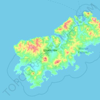
Nome: Mappa topografica Shikotan, altitudine, rilievo.
Altitudine media: 31 m
Altitudine minima: -1 m
Altitudine massima: 411 m
Fai una donazione
Preparati per la tua prossima avventura:
In qualità di associato Amazon, questo sito riceve una commissione sugli acquisti idonei senza alcun costo aggiuntivo per te.