
Mappa topografica Angel Fire
Mappa interattiva
Clicca sulla mappa per visualizzare l'altitudine.
A proposito di questa mappa
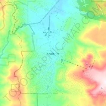
Nome: Mappa topografica Angel Fire, altitudine, rilievo.
Altitudine media: 2.786 m
Altitudine minima: 2.526 m
Altitudine massima: 3.361 m
Angel Fire is located in southwestern Colfax County at 36°22′44″N 105°17′8″W / 36.37889°N 105.28556°W / 36.37889; -105.28556 (36.378808, -105.285658). The village center is in the valley of Cieneguilla Creek, with housing developments climbing mountain slopes to the east and west. Angel Fire Resort, entirely within the village limits, is on the east side of the valley, with a base elevation of 8,600 feet (2,600 m) and a summit elevation of 10,677 feet (3,254 m). Agua Fria Peak, with a summit elevation of 11,078 feet (3,377 m), rises to the southeast of the ski area; the summit is near the southeast corner of the village limits.
Altre mappe topografiche
Clicca su una mappa per visualizzarne la topografia, l'altitudine e il rilievo.
Yankee
United States > New Mexico > Colfax County
Yankee, Colfax County, New Mexico, United States
Altitudine media: 2.249 m
Apache Spring
United States > New Mexico > Colfax County > Val Verde Ski Area
Apache Spring, Pam Coleman Drive, Val Verde Ski Area, Colfax County, New Mexico, 87710, United States
Altitudine media: 2.966 m
Cimarron
United States > New Mexico > Colfax County
Cimarron, Colfax County, New Mexico, 87714, United States
Altitudine media: 1.976 m
Idlewild
United States > New Mexico > Colfax County
Idlewild, Colfax County, New Mexico, 87718, United States
Altitudine media: 2.661 m
Raton
United States > New Mexico > Colfax County
Raton, Colfax County, New Mexico, 87740, United States
Altitudine media: 2.040 m
Baldy Mountain
United States > New Mexico > Colfax County
Baldy Mountain, Colfax County, New Mexico, United States
Altitudine media: 3.437 m