
Fai una donazione
Preparati per la tua prossima avventura:
In qualità di associato Amazon, questo sito riceve una commissione sugli acquisti idonei senza alcun costo aggiuntivo per te.
Mappa topografica Safford
Clicca sulla mappa per visualizzare l'altitudine.
Fai una donazione
Preparati per la tua prossima avventura:
In qualità di associato Amazon, questo sito riceve una commissione sugli acquisti idonei senza alcun costo aggiuntivo per te.
Safford
The climate is cold semi-arid (Köppen: BSk) softened by the plateau rise (it receives enough rainfall not to fall into a cold desert, BWk). It is much hotter than most places in eastern Arizona due to its relatively low elevation of 2,953 feet (900 m) at the Agricultural Center where records are kept, and often reaches temperatures almost as hot as found in Phoenix. In January, the average high temperature is 60 °F or 15.6 °C with a low of 29 °F or −1.7 °C. In July, the average high temperature is 98 °F or 36.7 °C with a low of 68 °F or 20 °C. Annual precipitation averages around 9.8 inches (248.9 mm), and snowfall is exceptionally rare: the mean is around 0.8 inches (0.020 m) but the median is zero.
Fai una donazione
Preparati per la tua prossima avventura:
In qualità di associato Amazon, questo sito riceve una commissione sugli acquisti idonei senza alcun costo aggiuntivo per te.
A proposito di questa mappa
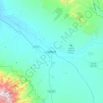
Nome: Mappa topografica Safford, altitudine, rilievo.
Luogo: Safford, Graham County, Arizona, 85548, United States (32.67395 -109.86758 32.99395 -109.54758)
Altitudine media: 1.113 m
Altitudine minima: 839 m
Altitudine massima: 3.257 m
Fai una donazione
Preparati per la tua prossima avventura:
In qualità di associato Amazon, questo sito riceve una commissione sugli acquisti idonei senza alcun costo aggiuntivo per te.