
Fai una donazione
Preparati per la tua prossima avventura:
In qualità di associato Amazon, questo sito riceve una commissione sugli acquisti idonei senza alcun costo aggiuntivo per te.
Mappa topografica Zamboanga City
Clicca sulla mappa per visualizzare l'altitudine.
Fai una donazione
Preparati per la tua prossima avventura:
In qualità di associato Amazon, questo sito riceve una commissione sugli acquisti idonei senza alcun costo aggiuntivo per te.
Zamboanga City
The overall topography of the city could be described as rolling to very steep. There are some flat lands, mostly narrow strips along the east coast. The urban center is mostly flat with a gentle slope to the interior, ranging from 0 to 3%. The highest registered elevation is 1,200 metres. In terms of slope, a large portion of Zamboanga City, about 38,000 hectares, have slopes ranging from 18 to 30%. Another 26,000 hectares have been described as having slopes of less than 3% while about 37% of the area or a total of 52,000 hectares have slopes ranging from 30% to more than 50%.
Fai una donazione
Preparati per la tua prossima avventura:
In qualità di associato Amazon, questo sito riceve una commissione sugli acquisti idonei senza alcun costo aggiuntivo per te.
A proposito di questa mappa
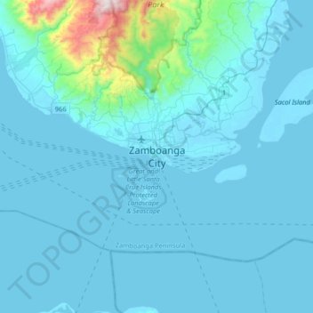
Nome: Mappa topografica Zamboanga City, altitudine, rilievo.
Luogo: Zamboanga City, Zamboanga Peninsula, 7000, Philippines (6.74460 121.91637 7.06460 122.23637)
Altitudine media: 83 m
Altitudine minima: -2 m
Altitudine massima: 1.201 m
Fai una donazione
Preparati per la tua prossima avventura:
In qualità di associato Amazon, questo sito riceve una commissione sugli acquisti idonei senza alcun costo aggiuntivo per te.