
Fai una donazione
Preparati per la tua prossima avventura:
In qualità di associato Amazon, questo sito riceve una commissione sugli acquisti idonei senza alcun costo aggiuntivo per te.
Mappa topografica Crater Lake
Clicca sulla mappa per visualizzare l'altitudine.
Fai una donazione
Preparati per la tua prossima avventura:
In qualità di associato Amazon, questo sito riceve una commissione sugli acquisti idonei senza alcun costo aggiuntivo per te.
Crater Lake
Il Crater presenta un clima subartico, con il raro tipo di estate secca (classificazione di Köppen Dsc) a causa della sua elevata altitudine e, come in tutto l'Oregon, della forte influenza nei mesi caldi dell'anticiclone delle Hawaii. In estate il clima è mite e secco, mentre in inverno diventa freddo e la potente influenza del ciclone aleutino genera enormi nevicate, con una media di 12,83 m all'anno e una copertura nevosa massima media pari a 3,53 m. Questa neve di solito non si scioglie fino a metà luglio e consente la formazione di ghiacciai consistenti sulle montagne adiacenti. Nell'inverno del 1949/1950 caddero fino a 22,48 m di neve, ma non si possono tralasciare i 4,88 m durante il 1981/1982. La nevicata giornaliera più abbondante ammontava a 94 cm, avvenuta il 28 febbraio 1971; 51 cm si depositarono sia a giugno che a settembre. Del gelo intenso è possibile anche in estate. Le temperature superficiali del lago variano tra l'1 e i 19 °C. Nei mesi caldi, la temperatura del lago si attesta in media tra i 10 e i 16 °C.
Fai una donazione
Preparati per la tua prossima avventura:
In qualità di associato Amazon, questo sito riceve una commissione sugli acquisti idonei senza alcun costo aggiuntivo per te.
A proposito di questa mappa
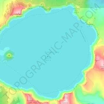
Nome: Mappa topografica Crater Lake, altitudine, rilievo.
Luogo: Crater Lake, Klamath County, Oregon, Stati Uniti d'America (42.90431 -122.16453 42.97874 -122.04998)
Altitudine media: 1.971 m
Altitudine minima: 1.853 m
Altitudine massima: 2.483 m
Fai una donazione
Preparati per la tua prossima avventura:
In qualità di associato Amazon, questo sito riceve una commissione sugli acquisti idonei senza alcun costo aggiuntivo per te.