
Mappa topografica Federal Territory of Kuala Lumpur
Mappa interattiva
Clicca sulla mappa per visualizzare l'altitudine.
A proposito di questa mappa
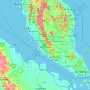
Nome: Mappa topografica Federal Territory of Kuala Lumpur, altitudine, rilievo.
Luogo: Federal Territory of Kuala Lumpur, Malaysia (0.59266 99.14222 5.71266 104.26222)
Altitudine media: 119 m
Altitudine minima: -3 m
Altitudine massima: 2.127 m
Located in the centre of Selangor state, Kuala Lumpur was a territory of Selangor State Government. In 1974, Kuala Lumpur was separated from Selangor to form the first Federal Territory governed directly by the Malaysian Federal Government. Its location within the most developed state on the west coast of Peninsular Malaysia, which has wider flat land than the east coast, has contributed to its faster development relative to other cities in Malaysia. The municipality of the city covers an area of 243 km2 (94 sq mi), with an average elevation of 81.95 m (268.9 ft).