
Mappa topografica Capelas
Mappa interattiva
Clicca sulla mappa per visualizzare l'altitudine.
A proposito di questa mappa
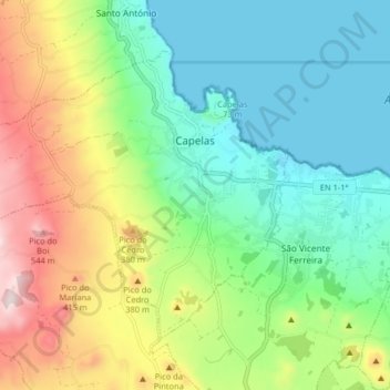
Nome: Mappa topografica Capelas, altitudine, rilievo.
Luogo: Capelas, Ponta Delgada, Azores, Portugal (37.80425 -25.75047 37.85171 -25.66940)
Altitudine media: 195 m
Altitudine minima: 0 m
Altitudine massima: 588 m
The first settlements congregated around the port of Poços, along the northern edge that divides Capelas from São Vicente Ferreira; its first settlers establishing shelters in and around the 16th Century. With elevation of Capelas to (religious) parish it became integrated within the municipality of Ponta Delgada (on 11 July 1592). This administrative dependency lasted until it was elevated to status of vila, as stipulated by the Carta de Lei (Charter Law) conferred by Queen D. Maria, on July 10, 1839.
Altre mappe topografiche
Clicca su una mappa per visualizzarne la topografia, l'altitudine e il rilievo.
São Vicente Ferreira
Portugal > Ponta Delgada > São Vicente Ferreira
São Vicente Ferreira, Ponta Delgada, Azores, Portugal
Altitudine media: 152 m