
Fai una donazione
Preparati per la tua prossima avventura:
In qualità di associato Amazon, questo sito riceve una commissione sugli acquisti idonei senza alcun costo aggiuntivo per te.
Mappa topografica Steptoe Butte
Clicca sulla mappa per visualizzare l'altitudine.
Fai una donazione
Preparati per la tua prossima avventura:
In qualità di associato Amazon, questo sito riceve una commissione sugli acquisti idonei senza alcun costo aggiuntivo per te.
A proposito di questa mappa
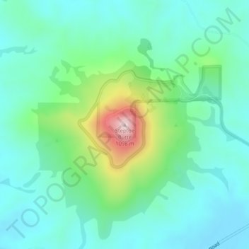
Nome: Mappa topografica Steptoe Butte, altitudine, rilievo.
Luogo: Steptoe Butte, Whitman County, Washington, United States (47.03234 -117.29718 47.03244 -117.29708)
Altitudine media: 832 m
Altitudine minima: 749 m
Altitudine massima: 1.100 m
Fai una donazione
Preparati per la tua prossima avventura:
In qualità di associato Amazon, questo sito riceve una commissione sugli acquisti idonei senza alcun costo aggiuntivo per te.
Altre mappe topografiche
Clicca su una mappa per visualizzarne la topografia, l'altitudine e il rilievo.
Pullman
United States > Washington > Whitman County
Pullman is situated within the Palouse region, characterized by its distinct topography of rolling hills formed from loess deposits—windblown silt accumulated over millennia. The city's average elevation is approximately 2,540 feet (774 meters), with elevations ranging from about 2,342 to 2,575 feet (714 to…
Altitudine media: 774 m
Fai una donazione
Preparati per la tua prossima avventura:
In qualità di associato Amazon, questo sito riceve una commissione sugli acquisti idonei senza alcun costo aggiuntivo per te.
Pullman
United States > Washington > Whitman County
The city is situated across several loess hills which characterize the Palouse Prairie, formed from windblown sediment over an estimated period of over one million years. This prairie region, the Palouse, is noteworthy for its fertile rolling hills where winter and spring wheat, barley, canola, lentils, and…
Altitudine media: 773 m
Pullman
United States > Washington > Whitman County
The city is situated across several loess hills which characterize the Palouse Prairie, formed from windblown sediment over an estimated period of over one million years. This prairie region, the Palouse, is noteworthy for its fertile rolling hills where winter and spring wheat, barley, canola, lentils, and…
Altitudine media: 774 m
Fai una donazione
Preparati per la tua prossima avventura:
In qualità di associato Amazon, questo sito riceve una commissione sugli acquisti idonei senza alcun costo aggiuntivo per te.
Pullman
United States > Washington > Whitman County
The city is situated across several loess hills which characterize the Palouse Prairie, formed from windblown sediment over an estimated period of over one million years. This prairie region, the Palouse, is noteworthy for its fertile rolling hills where winter and spring wheat, barley, canola, lentils, and…
Altitudine media: 774 m