
Mappa topografica James Island
Clicca sulla mappa per visualizzare l'altitudine.
James Island
James Island, one of British Columbia's Gulf Islands, lies in Haro Strait between Sidney Island and the coast of Vancouver Island near Sidney, British Columbia. James Island is approximately 2.4 km (1.5 mi) from the coast of Vancouver Island, and 145 km (90 mi) from Seattle, Washington. James Island has an elevation of 145 metres (476 feet) above sea level at its highest point, and has a total land-mass of 315 hectares (780 acres). There are sea-cliffs on the Southern, Western, and Eastern shores of this island. The Southern sea-cliffs are the highest.
A proposito di questa mappa
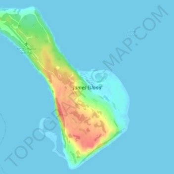
Nome: Mappa topografica James Island, altitudine, rilievo.
Altitudine media: 8 m
Altitudine minima: -1 m
Altitudine massima: 63 m
Altre mappe topografiche
Clicca su una mappa per visualizzarne la topografia, l'altitudine e il rilievo.
Mayne
Canada > British Columbia > Capital Regional District > Southern Gulf Islands Electoral Area
Altitudine media: 52 m
Mount Parke
Canada > British Columbia > Capital Regional District > Southern Gulf Islands Electoral Area
Altitudine media: 74 m
Galiano
Canada > British Columbia > Capital Regional District > Southern Gulf Islands Electoral Area
Altitudine media: 82 m
Mayne
Canada > British Columbia > Capital Regional District > Southern Gulf Islands Electoral Area
Altitudine media: 52 m
Mayne
Canada > British Columbia > Capital Regional District > Southern Gulf Islands Electoral Area
Altitudine media: 52 m