
Mappa topografica Springfield
Mappa interattiva
Clicca sulla mappa per visualizzare l'altitudine.
A proposito di questa mappa
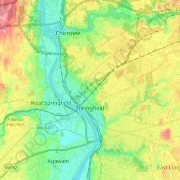
Nome: Mappa topografica Springfield, altitudine, rilievo.
Altitudine media: 50 m
Altitudine minima: 8 m
Altitudine massima: 115 m
Aside from its rivers, Springfield's second most prominent topographical feature is the city's 735-acre (297 ha) Forest Park. Forest Park lies in the southwestern corner of the city, surrounded by Springfield's attractive garden districts, Forest Park and Forest Park Heights, which feature over 600 Victorian Painted Lady mansions. Forest Park also borders Longmeadow. Springfield shares borders with other suburbs such as East Longmeadow, Wilbraham, Ludlow and the city of Chicopee. The small cities of Agawam and West Springfield lie less than a mile (1.6 km) from Springfield's Metro Center, across the Connecticut River.