
Fai una donazione
Preparati per la tua prossima avventura:
In qualità di associato Amazon, questo sito riceve una commissione sugli acquisti idonei senza alcun costo aggiuntivo per te.
Mappa topografica Lake Texoma
Clicca sulla mappa per visualizzare l'altitudine.
Fai una donazione
Preparati per la tua prossima avventura:
In qualità di associato Amazon, questo sito riceve una commissione sugli acquisti idonei senza alcun costo aggiuntivo per te.
Lake Texoma
Normal elevation of the conservation pool varies from 615 to 619 ft (187 to 189 m) National Geodetic Vertical Datum (NGVD) depending on the time of year. The flood control pool extends to elevation 645 ft (197 m) NGVD. The lake has crested the dam's spillway at a height of 640 ft (200 m) five times: once in 1957, again in 1990, 2007, May 24, 2015, and most recently on June 18, 2015. (USACE 2003a) The lake's previously highest elevation was recorded on May 6, 1990, at 644.76 feet. This record was broken on May 29, 2015, and the lake crested on June 1, 2015, at a new record elevation of 645.72 feet. The top of Denison Dam is at 670 feet.
Fai una donazione
Preparati per la tua prossima avventura:
In qualità di associato Amazon, questo sito riceve una commissione sugli acquisti idonei senza alcun costo aggiuntivo per te.
A proposito di questa mappa
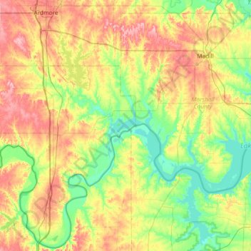
Nome: Mappa topografica Lake Texoma, altitudine, rilievo.
Luogo: Lake Texoma, Marshall County, Oklahoma, United States (33.71228 -97.06889 34.16391 -96.51384)
Altitudine media: 213 m
Altitudine minima: 148 m
Altitudine massima: 308 m
Fai una donazione
Preparati per la tua prossima avventura:
In qualità di associato Amazon, questo sito riceve una commissione sugli acquisti idonei senza alcun costo aggiuntivo per te.
Altre mappe topografiche
Clicca su una mappa per visualizzarne la topografia, l'altitudine e il rilievo.