
Mappa topografica Chakrata
Clicca sulla mappa per visualizzare l'altitudine.
Chakrata
It lies between the Tons and Yamuna rivers, at an elevation of 2118 m, 98 km from the state capital, Dehradun. Chakrata was originally a cantonment of the British Indian Army. To the west lies Shillai, Himachal Pradesh, and to the east are Mussoorie (73 km) and Tehri Garhwal.
A proposito di questa mappa
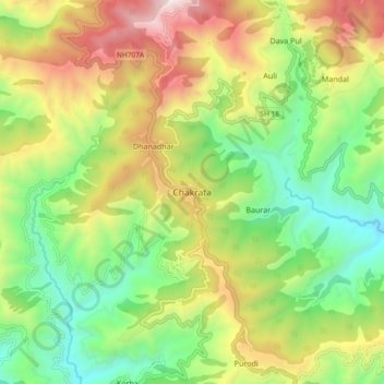
Nome: Mappa topografica Chakrata, altitudine, rilievo.
Luogo: Chakrata, Dehradun, Uttarakhand, 248123, India (30.66132 77.83034 30.74132 77.91034)
Altitudine media: 1.851 m
Altitudine minima: 1.220 m
Altitudine massima: 2.780 m