
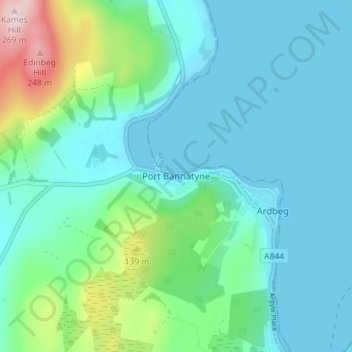
Mappa topografica Port Bannatyne
Mappa interattiva
Clicca sulla mappa per visualizzare l'altitudine.
A proposito di questa mappa
Nome: Mappa topografica Port Bannatyne, altitudine, rilievo.
Altitudine media: 52 m
Altitudine minima: -3 m
Altitudine massima: 267 m
Altre mappe topografiche
Clicca su una mappa per visualizzarne la topografia, l'altitudine e il rilievo.
Iona
United Kingdom > Scotland > Argyll and Bute > The Village
Iona, The Village, Argyll and Bute, Scotland, United Kingdom
Altitudine media: 9 m
Sandbank
United Kingdom > Scotland > Argyll and Bute
Sandbank, Argyll and Bute, Scotland, PA23 8PJ, United Kingdom
Altitudine media: 100 m
Tiree
United Kingdom > Scotland > Argyll and Bute > Balevullin
Tiree, Balevullin, Argyll and Bute, Scotland, United Kingdom
Altitudine media: 3 m
Colonsay
United Kingdom > Scotland > Argyll and Bute > Scalasaig
Colonsay, Scalasaig, Argyll and Bute, Scotland, United Kingdom
Altitudine media: 11 m
Loch Etive
United Kingdom > Scotland > Argyll and Bute > Connel
Loch Etive, Connel, Argyll and Bute, Scotland, United Kingdom
Altitudine media: 318 m
Calgary
United Kingdom > Scotland > Argyll and Bute
Calgary, Argyll and Bute, Scotland, PA75 6QU, United Kingdom
Altitudine media: 109 m
Campbeltown
United Kingdom > Scotland > Argyll and Bute > Campbeltown
Campbeltown, Argyll and Bute, Scotland, PA28 6AD, United Kingdom
Altitudine media: 84 m
Rothesay
United Kingdom > Scotland > Argyll and Bute
Rothesay, Argyll and Bute, Scotland, PA20 2AA, United Kingdom
Altitudine media: 38 m
Staffa
United Kingdom > Scotland > Argyll and Bute
Staffa, Argyll and Bute, Scotland, United Kingdom
Altitudine media: 0 m
North Connel
United Kingdom > Scotland > Argyll and Bute
North Connel, Argyll and Bute, Scotland, PA37 1PL, United Kingdom
Altitudine media: 19 m
Tobermory
United Kingdom > Scotland > Argyll and Bute
Tobermory, Argyll and Bute, Scotland, United Kingdom
Altitudine media: 58 m