
Mappa topografica Stringtown
Clicca sulla mappa per visualizzare l'altitudine.
A proposito di questa mappa
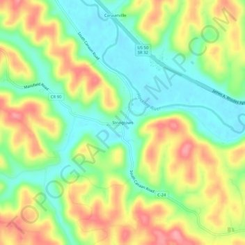
Nome: Mappa topografica Stringtown, altitudine, rilievo.
Altitudine media: 230 m
Altitudine minima: 183 m
Altitudine massima: 290 m
Altre mappe topografiche
Clicca su una mappa per visualizzarne la topografia, l'altitudine e il rilievo.
Amesville
United States > Ohio > Athens County
Amesville is situated in the foothills of the Appalachian Mountains, approximately 45 miles south by southeast of the terminal moraine, a topographical feature often associated with the boundaries of glaciers, and is surrounded by wooded hills, narrow valleys, and numerous creeks flanked by lowland pastures…
Altitudine media: 223 m