
Mappa topografica Lac de Gaube
Mappa interattiva
Clicca sulla mappa per visualizzare l'altitudine.
A proposito di questa mappa
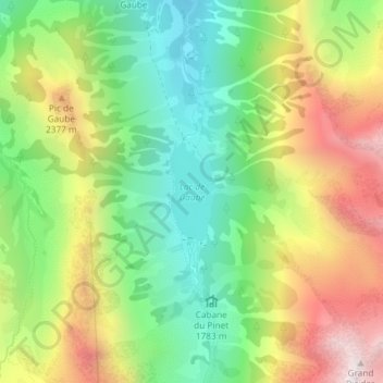
Nome: Mappa topografica Lac de Gaube, altitudine, rilievo.
Altitudine media: 2.079 m
Altitudine minima: 1.642 m
Altitudine massima: 2.689 m
The lake is situated in an altitude of 1725 m, an egg-shaped form stretching itself along a north–south axis in the valley of Gaube. This steep-sided valley is located at the foot of the Vignemale (3298M). The lake is surrounded by the peak Mayouret (2688 m) to the east, the big Peak of the Paloumères (2720 m) to the southeast, and the peak of Gaube (2377 m) to the northwest.
Altre mappe topografiche
Clicca su una mappa per visualizzarne la topografia, l'altitudine e il rilievo.
Vue sur Cascades et Pont d'Espagne
France > Occitania > Hautes Pyrenees > Cauterets
Vue sur Cascades et Pont d'Espagne, Pont d'Espagne, Cauterets, Argelès-Gazost, Hautes Pyrenees, Occitania, Metropolitan France, 65110, France
Altitudine media: 1.827 m