
Mappa topografica Village of Mohawk
Mappa interattiva
Clicca sulla mappa per visualizzare l'altitudine.
A proposito di questa mappa
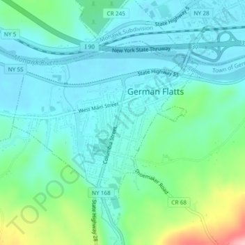
Nome: Mappa topografica Village of Mohawk, altitudine, rilievo.
Altitudine media: 148 m
Altitudine minima: 114 m
Altitudine massima: 270 m
Altre mappe topografiche
Clicca su una mappa per visualizzarne la topografia, l'altitudine e il rilievo.
Dennison Corners
United States > New York > Herkimer County > Town of German Flatts
Dennison Corners, Town of German Flatts, Herkimer County, New York, 13407, United States
Altitudine media: 404 m
Edicks
United States > New York > Herkimer County > Town of German Flatts
Edicks, Town of German Flatts, Herkimer County, New York, United States
Altitudine media: 355 m
South Ilion
United States > New York > Herkimer County > Town of German Flatts
South Ilion, Town of German Flatts, Herkimer County, New York, United States
Altitudine media: 239 m
Days Rock
United States > New York > Herkimer County > Town of German Flatts
Days Rock, Town of German Flatts, Herkimer County, New York, 13407, United States
Altitudine media: 317 m
Fort Herkimer
United States > New York > Herkimer County > Town of German Flatts
Fort Herkimer, Town of German Flatts, Herkimer County, New York, 13350, United States
Altitudine media: 177 m
Village of Ilion
United States > New York > Herkimer County > Town of German Flatts
Village of Ilion, Town of German Flatts, Herkimer County, New York, 13357, United States
Altitudine media: 151 m