
Mappa topografica Laramie
Mappa interattiva
Clicca sulla mappa per visualizzare l'altitudine.
A proposito di questa mappa
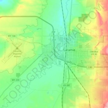
Nome: Mappa topografica Laramie, altitudine, rilievo.
Luogo: Laramie, Albany County, Wyoming, United States (41.27742 -105.69729 41.33581 -105.52819)
Altitudine media: 2.219 m
Altitudine minima: 2.166 m
Altitudine massima: 2.462 m
Laramie (/ˈlærəmi/) is a city in and the county seat of Albany County, Wyoming, United States, known for its high elevation at 7,200 feet (2,200 m), railroad history, and as the higher-education center for the state of Wyoming. The population was estimated 31,407 in 2020, making it the 4th most populous city in Wyoming. Located on the Laramie River in southeastern Wyoming, the city is west of Cheyenne and 25 miles (40 km) north of the Colorado state line, at the junction of Interstate 80 and U.S. Route 287.
Altre mappe topografiche
Clicca su una mappa per visualizzarne la topografia, l'altitudine e il rilievo.
Chalk Bluff
United States > Wyoming > Albany County
Chalk Bluff, Albany County, Wyoming, United States
Altitudine media: 2.153 m
Laramie
United States > Wyoming > Albany County > Laramie
Laramie, Albany County, Wyoming, 82070, United States
Altitudine media: 2.299 m