
Mappa topografica Kandukur
Mappa interattiva
Clicca sulla mappa per visualizzare l'altitudine.
A proposito di questa mappa
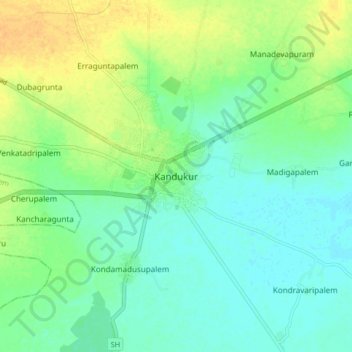
Nome: Mappa topografica Kandukur, altitudine, rilievo.
Altitudine media: 18 m
Altitudine minima: 7 m
Altitudine massima: 36 m
Kandukuru (earlier known as Skandapuri) is located at 15°12′59″N 79°54′15″E / 15.2165°N 79.9042°E / 15.2165; 79.9042. It has an average elevation of 13 metres (43 ft). Kandukur was a part of the erstwhile Nellore district and was then included in the newly carved out Prakasam District in 1970. Later as a part of the district's reorganization in 2022, it is now merged with the residual SPSR Nellore district. The total geographical area of Kandukur Municipality is 37.63 sq km.
Altre mappe topografiche
Clicca su una mappa per visualizzarne la topografia, l'altitudine e il rilievo.
Chuttugunta
India > Andhra Pradesh > Kandukur
Chuttugunta, Kandukur, Sri Potti Sriramulu Nellore District, Andhra Pradesh, India
Altitudine media: 10 m
Kandukur
India > Andhra Pradesh > Kandukur
Kandukur, Sri Potti Sriramulu Nellore, Andhra Pradesh, 523105, India
Altitudine media: 20 m