
Fai una donazione
Preparati per la tua prossima avventura:
In qualità di associato Amazon, questo sito riceve una commissione sugli acquisti idonei senza alcun costo aggiuntivo per te.
Mappa topografica Richmond
Clicca sulla mappa per visualizzare l'altitudine.
Fai una donazione
Preparati per la tua prossima avventura:
In qualità di associato Amazon, questo sito riceve una commissione sugli acquisti idonei senza alcun costo aggiuntivo per te.
Richmond
According to the United States Census Bureau, the town has a total area of 37.7 square miles (97.7 km2), of which 37.5 square miles (97.2 km2) are land and 0.19 square miles (0.5 km2) are water, comprising 0.52% of the town. Little Monadnock Mountain, elevation 1,883 feet (574 m) above sea level, is within a mile of the eastern boundary, in the town of Fitzwilliam. The highest point in Richmond is one mile northwest of Little Monadnock, on an unnamed hill whose elevation is 1,624 feet (495 m) above sea level. The Franconia Mountain Range (not to be confused with the much higher ridge in the White Mountains to the north) is a 1,300-foot-high (400 m) chain of hills in the western part of town.
Fai una donazione
Preparati per la tua prossima avventura:
In qualità di associato Amazon, questo sito riceve una commissione sugli acquisti idonei senza alcun costo aggiuntivo per te.
A proposito di questa mappa
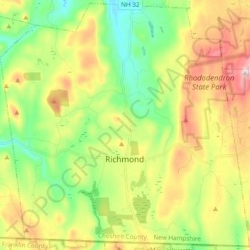
Nome: Mappa topografica Richmond, altitudine, rilievo.
Luogo: Richmond, Cheshire County, New Hampshire, United States (42.71971 -72.33971 42.81701 -72.20371)
Altitudine media: 321 m
Altitudine minima: 157 m
Altitudine massima: 565 m
Fai una donazione
Preparati per la tua prossima avventura:
In qualità di associato Amazon, questo sito riceve una commissione sugli acquisti idonei senza alcun costo aggiuntivo per te.
Altre mappe topografiche
Clicca su una mappa per visualizzarne la topografia, l'altitudine e il rilievo.
West Chesterfield
United States > New Hampshire > Cheshire County > Chesterfield
Altitudine media: 168 m
Camp Notre Dame
United States > New Hampshire > Cheshire County > Chesterfield
Altitudine media: 223 m
Fai una donazione
Preparati per la tua prossima avventura:
In qualità di associato Amazon, questo sito riceve una commissione sugli acquisti idonei senza alcun costo aggiuntivo per te.
Fai una donazione
Preparati per la tua prossima avventura:
In qualità di associato Amazon, questo sito riceve una commissione sugli acquisti idonei senza alcun costo aggiuntivo per te.
Fai una donazione
Preparati per la tua prossima avventura:
In qualità di associato Amazon, questo sito riceve una commissione sugli acquisti idonei senza alcun costo aggiuntivo per te.
Scotland
United States > New Hampshire > Cheshire County > Winchester > Scotland
Altitudine media: 209 m
Alstead Center
United States > New Hampshire > Cheshire County > Alstead > Alstead Center
Altitudine media: 371 m
Fai una donazione
Preparati per la tua prossima avventura:
In qualità di associato Amazon, questo sito riceve una commissione sugli acquisti idonei senza alcun costo aggiuntivo per te.
Longmeadow Subdivision
United States > New Hampshire > Cheshire County > Keene
Altitudine media: 179 m