
Fai una donazione
Preparati per la tua prossima avventura:
In qualità di associato Amazon, questo sito riceve una commissione sugli acquisti idonei senza alcun costo aggiuntivo per te.
Mappa topografica Raystown Lake
Clicca sulla mappa per visualizzare l'altitudine.
Fai una donazione
Preparati per la tua prossima avventura:
In qualità di associato Amazon, questo sito riceve una commissione sugli acquisti idonei senza alcun costo aggiuntivo per te.
Raystown Lake
The proposal for the new dam incorporated the ideas of bringing tourism into the area, promoting recreation, and flood control. The actual purpose stated, "The project will provide flood control, recreation, water quality and fish and wildlife enhancement" (U.S. Army Corps of Engineers, 1974). Although tourism and recreation was what was projected as the most important to the public and community, the reason the dam was approved was for flood control. The project was authorized under the general provisions of the Flood Control Act of 1962 (Public Law 87-874, 87th Congress, second session). The dam has a flood storage capacity of 247,900 acre-feet (305,800,000 m3), equivalent to about 5 inches (13 cm) of runoff from the drainage area of 960 square miles (2,500 km2) above the dam, between elevations of 786 and 812 (U.S. Army Corps of Engineers, 1965). "The project would reduce flood stages along the Juniata River at Mount Union, Lewistown, Mifflin, and Newport, Pennsylvania, and to a lesser extent, along the main stem of the Susquehanna River below the mouth of the Juniata River" (U.S. Army Corps of Engineers, 1965).
Fai una donazione
Preparati per la tua prossima avventura:
In qualità di associato Amazon, questo sito riceve una commissione sugli acquisti idonei senza alcun costo aggiuntivo per te.
A proposito di questa mappa
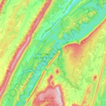
Nome: Mappa topografica Raystown Lake, altitudine, rilievo.
Altitudine media: 380 m
Altitudine minima: 206 m
Altitudine massima: 712 m
Fai una donazione
Preparati per la tua prossima avventura:
In qualità di associato Amazon, questo sito riceve una commissione sugli acquisti idonei senza alcun costo aggiuntivo per te.
Altre mappe topografiche
Clicca su una mappa per visualizzarne la topografia, l'altitudine e il rilievo.