
Fai una donazione
Preparati per la tua prossima avventura:
In qualità di associato Amazon, questo sito riceve una commissione sugli acquisti idonei senza alcun costo aggiuntivo per te.
Mappa topografica Irving
Clicca sulla mappa per visualizzare l'altitudine.
Fai una donazione
Preparati per la tua prossima avventura:
In qualità di associato Amazon, questo sito riceve una commissione sugli acquisti idonei senza alcun costo aggiuntivo per te.
Irving
Irving is a hamlet in Chautauqua County, New York, United States. (It also falls in Cattaraugus County and Erie County. The Cattaraugus County part of Irving is part of the Seneca Nation Native American territory, the Erie County part borders Brant, New York and also is part of the Seneca Nation territory. ) It is located near the eastern town line and the eastern county line in the town of Hanover. U.S. Route 20 and New York State Route 5 pass through the hamlet, which is next to Cattaraugus Creek; New York State Route 438 terminates just across the creek. The elevation of the hamlet is 584 feet (178 m) above sea level. The ZIP Code for Irving is 14081.
Fai una donazione
Preparati per la tua prossima avventura:
In qualità di associato Amazon, questo sito riceve una commissione sugli acquisti idonei senza alcun costo aggiuntivo per te.
A proposito di questa mappa
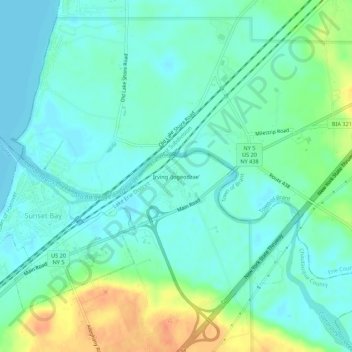
Nome: Mappa topografica Irving, altitudine, rilievo.
Altitudine media: 185 m
Altitudine minima: 172 m
Altitudine massima: 216 m
Fai una donazione
Preparati per la tua prossima avventura:
In qualità di associato Amazon, questo sito riceve una commissione sugli acquisti idonei senza alcun costo aggiuntivo per te.
Altre mappe topografiche
Clicca su una mappa per visualizzarne la topografia, l'altitudine e il rilievo.
Fai una donazione
Preparati per la tua prossima avventura:
In qualità di associato Amazon, questo sito riceve una commissione sugli acquisti idonei senza alcun costo aggiuntivo per te.
Village of Cassadaga
United States > New York > Chautauqua County > Town of Stockton
Cassadaga is located on the northwestern edge of the Allegheny Plateau in western New York at 42°20'29" north, 79°18'56" west (42.341343, -79.315653) at an elevation of approximately 1,340 feet (410 m) above sea level. The village is located at the south end of Lower Cassadaga Lake, Lily Dale being located…
Altitudine media: 418 m
Fai una donazione
Preparati per la tua prossima avventura:
In qualità di associato Amazon, questo sito riceve una commissione sugli acquisti idonei senza alcun costo aggiuntivo per te.
Fai una donazione
Preparati per la tua prossima avventura:
In qualità di associato Amazon, questo sito riceve una commissione sugli acquisti idonei senza alcun costo aggiuntivo per te.
Fai una donazione
Preparati per la tua prossima avventura:
In qualità di associato Amazon, questo sito riceve una commissione sugli acquisti idonei senza alcun costo aggiuntivo per te.
Chautauqua Lake
United States > New York > Chautauqua County > Bemus Point
Chautauqua Lake, at an elevation of 1,308 feet (399 m) above sea level, is higher than any of the Finger Lakes. It is also one of the highest navigable lakes in North America. The lake's water level is regulated by Warner Dam, with the water level lifted during the summer to allow for recreational boat use and…
Altitudine media: 463 m
Village of Celoron
United States > New York > Chautauqua County > Town of Ellicott
Altitudine media: 410 m
Fai una donazione
Preparati per la tua prossima avventura:
In qualità di associato Amazon, questo sito riceve una commissione sugli acquisti idonei senza alcun costo aggiuntivo per te.
Jamestown West
United States > New York > Chautauqua County > Town of Ellicott
Altitudine media: 441 m
Fai una donazione
Preparati per la tua prossima avventura:
In qualità di associato Amazon, questo sito riceve una commissione sugli acquisti idonei senza alcun costo aggiuntivo per te.