
Mappa topografica Siġġiewi
Mappa interattiva
Clicca sulla mappa per visualizzare l'altitudine.
A proposito di questa mappa
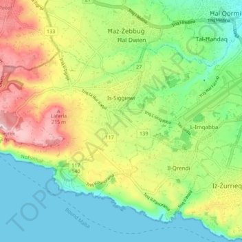
Nome: Mappa topografica Siġġiewi, altitudine, rilievo.
Luogo: Siġġiewi, Southern Region, Malta (35.82602 14.38956 35.86856 14.47248)
Altitudine media: 93 m
Altitudine minima: 0 m
Altitudine massima: 250 m
In its demographic and topographical formation, Siġġiewi followed a pattern common to other villages in Malta. Before the arrival of the Order of St John in 1530, there were other thriving hamlets in the area. Little by little, Ħal Xluq, Ħal Kbir, Ħal Niklusi, and Ħal Qdieri were absorbed in Siġġiewi and today only their secluded chapels remain.
Altre mappe topografiche
Clicca su una mappa per visualizzarne la topografia, l'altitudine e il rilievo.
Malta
Malta, Southern Region, Sovereign Military Hospitaller Order of Saint John of Jerusalem, of Rhodes and of Malta, Malta
Altitudine media: 37 m
Blue Grotto
Malta > Southern Region > Żurrieq
Blue Grotto, Triq il-Wied, Żurrieq, Southern Region, QRD 3043, Malta
Altitudine media: 61 m