
Mappa topografica Cocoa
Clicca sulla mappa per visualizzare l'altitudine.
A proposito di questa mappa
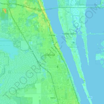
Nome: Mappa topografica Cocoa, altitudine, rilievo.
Luogo: Cocoa, Brevard County, Florida, United States (28.23185 -80.82081 28.41841 -80.72107)
Altitudine media: 5 m
Altitudine minima: -2 m
Altitudine massima: 30 m
Altre mappe topografiche
Clicca su una mappa per visualizzarne la topografia, l'altitudine e il rilievo.
Whispering Hills Golf Estates
United States > Florida > Brevard County > Titusville
Altitudine media: 6 m
Cape Canaveral
United States > Florida > Brevard County
The hurricane of August 1885, pushed a "wall of water" over the barrier island (elevation, 3.1 m (10 ft)) devastating Cape Canaveral and adjacent areas. The ocean waves flooded the homesteaders and discouraged further settlement in the area. The beach near the lighthouse was severely eroded prompting its…
Altitudine media: 1 m
Georgiana
United States > Florida > Brevard County
Georgiana is a populated place located on Merritt Island in Brevard County, Florida at latitude 28.288673N and longitude 80.671398W. The elevation is 10 feet. It is about five miles south of the 520 Causeway, situated where the island is about a half-mile wide.
Altitudine media: 1 m