
Mappa topografica Colliford Lake
Clicca sulla mappa per visualizzare l'altitudine.
A proposito di questa mappa
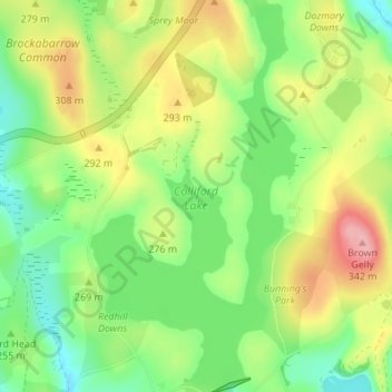
Nome: Mappa topografica Colliford Lake, altitudine, rilievo.
Luogo: Colliford Lake, Cornwall, England, United Kingdom (50.50986 -4.59389 50.55309 -4.55800)
Altitudine media: 264 m
Altitudine minima: 212 m
Altitudine massima: 339 m
Altre mappe topografiche
Clicca su una mappa per visualizzarne la topografia, l'altitudine e il rilievo.
Bude
United Kingdom > England > Cornwall
Its earlier importance was as a harbour, and then a source of sea sand useful for improving the inland soil. This was transported on the Bude Canal. The Victorians favoured it as a seaside resort. With new rail links, it became a popular seaside destination in the 20th century. Bradshaw's Guide of 1866,…
Altitudine media: 41 m
St. Columb Major
United Kingdom > England > Cornwall
St Columb occupies a plateau at about 300 feet (91 m) elevation. The north part of the town (known as 'Bridge') descends into the Vale of Lanherne, having a minimum elevation of approximately 165 feet (50 m). It was originally a linear settlement built on the main road running north-east to south-west, but…
Altitudine media: 110 m